Frank Lloyd Wright is said to have quipped, “Tip the world over on its side and everything loose will land in Los Angeles,” a quote that has since been repeated both by those who love and hate L.A. The “City of Angels” is a city of sharp contrasts, home to people who hail from all parts of the globe and an important center of culture, business, media, and international trade. However, it’s most famous for being a major center of the world’s television, motion picture, and music industry, which forms the base of the city’s status and lures visitors for its show business history and celebrity culture. Visitors are also drawn to Los Angeles for its Mediterranean climate and numerous beaches, which gave birth to California’s famed surf culture.
California‘s most populous city and the second most populous city in the United States (after New York City), Los Angeles is spread across a broad basin in Southern California surrounded by vast forested mountain ranges, valleys, the Pacific Ocean, and nearby desert. Los Angeles sits at the heart of a metropolitan area of over 18 million people that spreads across Los Angeles County, Orange County, Ventura County, and the Inland Empire region of San Bernardino County and Riverside County.
Districts
For travel purposes, this guide covers the entirety of Los Angeles County, a region of nearly 5,000 square miles in Southern California (roughly the same size as Rhode Island). There are 88 cities (municipalities) in the county; the largest, the city of Los Angeles, spreads throughout the county from the Port of Los Angeles to the San Fernando Valley.
Central Los Angeles

| Downtown L.A. The central business district and historic center of Los Angeles, which has seen a booming revival in recent years with new museums, performing arts venues, trendy hotels, bars, shops and restaurants. |
| Eastside In the hills east of the downtown area is the Hispanic center of Los Angeles. This area is mostly residential in character, with a few scattered attractions. |
| Hollywood The historic and spiritual heart of the entertainment industry, with many tourist attractions paying tribute to the film and television stars of the past and where many movies still have their public premieres. |
| Northwest L.A. A funkier area in the heights north of Downtown and east of Hollywood that includes some rapidly gentrifying neighborhoods and the expansive Griffith Park, with its zoo, museums, and famous observatory. |
| South Central L.A. Though it has long had a reputation for gang violence and is the infamous site of the Rodney King riots, this area has mellowed significantly in the years since. While it remains off most people’s radar, there are some highlights including the Watts Towers and the science museums of Exposition Park. |
| Wilshire Home to the Miracle Mile District of Wilshire Boulevard, with its historic architecture and museums near the La Brea Tar Pits. Nearby are the studios, shops and entertainment of the Fairfax District. |
Los Angeles County regions

| Antelope Valley The arid northern region of the county beyond the San Gabriel Mountains; high desert and more rural in feel, but with a growing population amidst the rugged terrain. |
| Gateway Cities The mostly suburban and industrial southern region of the county, bordering Orange County. The largest city here is the harbor city of Long Beach, where you will find some highlights like the Aquarium of the Pacific and the Queen Mary. |
| San Fernando Valley “The Valley” is a sprawling suburban section of Los Angeles on the backside of the Hollywood Hills, home to a lot of the major motion picture studios and the popular Universal Studios theme park in the Studio City–Burbank–Glendale corridor. |
| San Gabriel Valley Encompassing the suburban valley communities east of Downtown Los Angeles, as well as the forested San Gabriel Mountains to the north of the valley. Sitting at the foot of the mountains is Pasadena, site of the Rose Parade and the Rose Bowl on New Year’s Day. |
| Santa Clarita Valley Far to the north of Los Angeles proper, this valley holds rugged canyon scenery, many ranches in the hills above the valley, and the Six Flags Magic Mountain theme park. |
| South Bay The beachfront and harbor communities of the county south of LAX, with popular surfing beaches, the picturesque coastline of Palos Verdes, and the launching point for ferries to Catalina Island. |
| Westside The affluent area of Los Angeles made famous by television and movies, where the elite of the entertainment industry reside. Home to the upscale communities of Bel-Air, Malibu, Pacific Palisades, West Hollywood, the high-end shopping of Beverly Hills, the classic film studios of Culver City, and the popular seaside towns of Santa Monica and Venice Beach. |
Understand
Geography
The city of Los Angeles is huge, stretching from the suburbs of the San Fernando Valley in the north to the Port of Los Angeles in the south, a distance of almost 50 miles. And that’s just the primary city; the sprawling L.A. metropolitan area spreads across portions of five counties and includes numerous smaller cities, some of which are regional centers of their own, like Burbank, Pasadena, Long Beach, Anaheim, Santa Ana, Riverside and San Bernardino. Some of these cities were founded around the end of the nineteenth century and grew alongside Los Angeles, and even today retain distinct identities.
Such is the nature of Los Angeles: because it is so spread out and its individual cities and neighborhoods are so distinct, the city is often thought of less as a cohesive whole than as a collection of disparate communities. Even some of the neighborhoods officially within the city of Los Angeles are so well-known that they are often thought to be distinct from the city, such as Hollywood, Van Nuys, Bel-Air, and Venice Beach, which sit astride officially independent municipalities such as West Hollywood, Santa Monica, and Beverly Hills.
Most of the city sits in a broad basin that stretches from Santa Monica along the shoreline across the southern portion of the county and into Orange County. The basin is the most intensely developed part of the region, with a strong grid pattern of streets and freeways that’s evident from the air. This basin is framed on the north by the Santa Monica Mountains, which gradually soften into a series of hills as they run east past Hollywood and Downtown L.A. and through East L.A. On the other side of these hills are two heavily developed valleys, the San Fernando Valley to the northwest of Central L.A. and the San Gabriel to the east, which today are filled with suburban neighborhoods. North of the valleys are the steep San Gabriel Mountains, which reach a high enough elevation that their peaks are sometimes coated with snow in the winter. Beyond this lies the Mojave Desert.
History
Prior to European contact, the Los Angeles basin was occupied by the native Tongva people, a set of hunter-gatherer tribes that were spread across much of Southern California. Portuguese explorer Juan Cabrillo was the first European to visit the region, sailing along the coast in 1542 and claiming the land for the Spanish Empire, but it took over two hundred years for the first Spanish settlement to be established, with the construction of the Mission San Gabriel by Franciscan missionaries in 1771. Ten years later, a group of Spanish settlers known as “Los Pobladores” (“the townspeople”) founded a small village, El Pueblo de Los Angeles, at the site of the present-day El Pueblo district near Downtown.
Los Angeles remained a small ranch town for several decades, passing to Mexican and then to American rule in 1847 in the wake of the Mexican–American War. Los Angeles was immediately turned into a boomtown with the completion of railroads to the region, first the Southern Pacific Railroad from the north in 1876 and then the Santa Fe Railroad from the east in 1885, establishing the city as a railroad hub of the west. At the same time, city boosters sought to establish port and industrial facilities to challenge San Francisco’s dominance on the west coast. Intense real estate speculation and low railroad fares attracted many “folks” from the Midwest and East Coast with warm winters and good job prospects. The discovery of oil in the basin and the completion of an aqueduct to provide a steady supply of water only accelerated the city’s growth.
Filmmakers began arriving in the 1900s, lured by the area’s climate and varied scenery, but also to flee Thomas Edison’s litigious motion picture company, whose patents weren’t enforced in the west. D.W. Griffith was the first to film a motion picture in the city, heralding the arrival of Hollywood. Soon, the vast majority of the world’s film industry was concentrated in Los Angeles, making the city known throughout the world. Los Angeles continued to grow, drawing waves of job seekers during the Great Depression, and by the 1940s had the largest streetcar network in the world. World War II turned the city into a major center of wartime manufacturing, with Los Angeles briefly serving as the aviation center of the nation.
After World War II, Los Angeles sprawled out even further into new suburbs, fueled by the construction of new freeways and arterial streets, with the streetcar network giving way before the popularity of the automobile. This turned Los Angeles into the car-centric city it is today, with the infamous traffic jams and air pollution to go with it. As white flight created a very racially segregated inner city, the 1960s saw racial tensions erupt into the Watts Riots, a situation largely repeated in 1992 with the Rodney King riots, while crime and gang violence in the central city rose. Nevertheless, the population of the city continued to grow, drawing a remarkable diversity of immigrants from throughout the Pacific Rim and Latin America.
Since the early 1990s, the city has seen a decrease in crime and renewed investment in urban development and revitalization. Much of the manufacturing industry has moved elsewhere, but the ports of Los Angeles and Long Beach are now the largest harbor complex in the nation, handling much of the United States’ imported goods. After decades of underinvestment, the city’s public transit system has seen massive expansion and improvement in recent years, bolstered by popular support for several countywide ballot measures to fund new construction. America’s entertainment industry remains largely headquartered in Los Angeles, and between the warm weather and attractions both new and old, the city continues to draw people from around the world.
People
Los Angeles is a very diverse city with much of its population being born outside the United States. The city has the third largest Mexican population in the world, behind the Mexican cities of Mexico City and Guadalajara, and is home to about a dozen other large immigrant populations, many with their own little enclaves of restaurants, shops, and places of worship; some prominent examples include Chinatown and Little Tokyo in the Downtown area, Koreatown, the Little Armenia district of East Hollywood, and Iranian, Indian, Pakistani, and Japanese enclaves in West L.A. On the south side of the county, Long Beach has a very diverse population while Carson is noted for its large Samoan population.
The Latino population is spread throughout the city, but is still most heavily concentrated in East L.A. South Central L.A. remains the African-American center of the city, even while experiencing an increase in the Hispanic population. Prominent gay communities are found in West Hollywood, as well as the Silver Lake neighborhood and the broader Westside area.
Climate
The city enjoys a temperate Mediterranean climate most of the year. However, the climate of Southern California is somewhat complex and temperatures can fluctuate wildly depending where you are in the city, since the varied terrain results in a series of microclimates. On the same day, daytime highs can vary by as much as twenty degrees Fahrenheit between coastal locations and cities in the San Fernando and San Gabriel Valleys. The coast tends to stay a bit cooler, which helps with the summer heat, but as such is also chillier at night. Bring a sweater and pants if you stay for dinner near the coast, even in the summer.
Summers are warm, occasionally hot, and bring the infamous dirty smog, though the air quality has significantly improved over the years. In July through September, the hottest months, average daytime highs in Downtown Los Angeles are 83°F (28°C) and nighttime lows average 63°F (17°C). Winters are mild and bring much of the annual rainfall; between December and March average daytime highs are 68°F (20°C) and nighttime lows are 49°F (9°C). Spring is a mix of gloomy rainy days and warm sunny days; like the rest of Southern California, L.A. experiences the “May Gray” and “June Gloom” marine effect, which results in frequent fog and overcast skies along the coast, so don’t expect sunny beach weather if you visit during these months. Fall has the same mix of rain and sun, though typically with more sunny days. Ocean temperatures along the L.A. coast vary from an average of 58°F (14°C) in January to 68°F (20°C) in August.
Santa Ana winds can occur at any time of the year, although they most commonly occur in the fall and winter. These winds are a reversal of the usual climate conditions, when hot, dry air blows from the desert to the coast. Milder Santa Ana winds can result in excellent dry air conditions, but powerful ones can last days on end, significantly raising temperatures, creating tremendous fire danger, and in general making life miserable.
Visitor information
- Los Angeles Visitor Information Center (Hollywood), 6801 Hollywood Blvd (in the Hollywood and Highland Center; Metro: Hollywood/Highland), ☎ +1 323 467-6412.
Get in
By plane
- See also: Air travel in the United States
The Los Angeles metro area is served by five major commercial airports and more than a dozen private airports. Three of the major airports are in L.A. County proper while the other two are nearby.

- Los Angeles International Airport (LAX IATA), 1 World Way, +1 310 646-5252. LAX is one of the major ports of entry for international flights to the United States as well as a major destination for domestic flights so it can be quite busy, especially around holidays. Nearly all major airlines as well as some smaller regional airlines fly into LAX. All of the major rental car agencies have a location near the airport with hundreds of cars available for rent.
- Bob Hope Airport (BUR IATA), 2627 N. Hollywood Way, Burbank, +1 818 840-8840. Alaska, American, Delta, JetBlue, SeaPort, Southwest, and United fly into this airport located in the San Fernando Valley, northeast of Downtown L.A.
- Long Beach Airport (LGB IATA), 4100 Donald Douglas Dr., Long Beach, +1 562 570-2600. American, Delta, and JetBlue fly into this airport located in southern Los Angeles County. It is also the west coast hub for JetBue.
- Ontario International Airport (ONT IATA), 1940 East Moore Way, Ontario in adjacent San Bernardino County, +1 909 937-2700. Aeromexico, Alaska, American, Delta, Southwest, United and Volaris serve this airport located 37 mi (59 km) east of Downtown Los Angeles, about a 40-minute drive without traffic.
- John Wayne Airport (SNA IATA), 18601 Airport Way, Santa Ana in adjacent Orange County, +1 949 252-5200. Alaska, American, Delta, Frontier, Southwest, United, and WestJet serve this airport located 40 mi (64 km) southeast of Downtown Los Angeles, about a 45-minute drive without traffic.
LAX is the airport many travelers use when visiting the Los Angeles area and is the far more likely point of entry if you’re on an international flight. LAX generally features lower fares and more nonstop and frequent service when compared to the other airports. Flying into LAX is the best option if this is the closest airport to your destination, and even if LAX is further away the fare is often simply too good to pass up. However, if your destination is closer (or almost as close) to one of the other four airports, and the fare really isn’t a huge difference, then consider those airports. For instance, if you plan to spend most of your time in the San Fernando Valley, there is the Bob Hope Airport in Burbank. If your visit will be centered around Orange County , Knotts Berry Farm and/or Disneyland, there’s the John Wayne Airport in Santa Ana or even the Long Beach Airport. If you will be staying in the Inland Empire or San Gabriel Valley in the east, there’s the Ontario Airport. These airports can save a lot of hassle because they are less busy than LAX. Also, the L.A. area is so wildly spread out and populated that going anywhere will generally require a lot of driving, as well as possibly enduring traffic jams. On any random day at any particular time (day or night), a traffic jam can develop and it is not unheard of to take an hour just to go a few miles on the freeway. So using the nearest airport will only be of convenience to you.
All five airports lack direct train services; only the Bob Hope Airport is somewhat proximate to a Metrolink commuter rail station (not to be confused with the Metro Rail service). LAX has a comfortable, fast, and relatively frequent express bus service, the LAX FlyAway, to a variety of regional centers including Union Station (in Downtown), Hollywood, and Westwood.
Private pilots will prefer smaller general aviation airports that do not handle commercial flights such as Santa Monica (SMO IATA), Van Nuys (VNY IATA), Hawthorne (HHR IATA), or any of the other small airports in the area that do not handle commercial flights. LAX does not cater to small general aviation; Bob Hope (BUR IATA) does, but is considered high-traffic for this type of flight; Long Beach (LGB IATA) does, but has a very complicated runway system and, again, is considered high traffic. Much of Los Angeles is Class Bravo or other controlled airspace, but due to the number of airports and the generally good weather, Los Angeles makes a fantastic flying destination.
By car
Several major freeways enter the Los Angeles region. Interstate 5 is the primary north/south freeway through Central L.A., heading south to the Mexican border through Orange County and San Diego, and heading north through the San Joaquin Valley to Sacramento, continuing on through the Pacific Northwest before eventually reaching Canada. From the south, Interstate 405 splits off from I-5 in Orange County and is a more direct route to Long Beach, the South Bay, and the Westside, so long as you don’t travel during rush hour. From the north, I-5 is the most direct option from the San Francisco Bay Area (linked to I-5 by I-580), while U.S. Highway 101 is the most direct option from California’s Central Coast.
From the east, Interstate 10 is the primary road into the region, heading east from L.A. through the Inland Empire and the California desert (via Palm Springs) before crossing through into Arizona and continuing across Texas, Louisiana, Alabama, Mississippi and the Florida panhandle to Jacksonville, FL.
And while they don’t directly connect to Los Angeles proper, Interstates 15 and 40 are important links from the north and east. I-15 runs north/south through the Inland Empire (where you can connect to several freeways to L.A. proper), continuing north through Nevada and Utah (via Las Vegas and Salt Lake City) and heading on through the Rocky Mountains (Idaho and Montana) to the Canadian border. I-40 is one of the nation’s primary east-west road links, cutting a long route across the middle of the country. In California, I-40 terminates at I-15 in the town of Barstow; from there, follow I-15 south into the Inland Empire and connect from there to Los Angeles.
If driving into or through the L.A. area, be sure to make note of when you’ll be arriving so as to try to avoid one of the area’s notorious traffic jams. See the Get around section below for more detailed info on getting around L.A. by car.
By train

Los Angeles’ main Amtrak and commuter train station is at Union Station, 800 N. Alameda St. next to the Hollywood Freeway (US-101) in Downtown Los Angeles. The station is a spectacular example of Mission Revival architecture, with a spacious waiting room and courtyards with outdoor seating, as well as some eating establishments on-site. It’s also well connected to L.A.’s public transit system, with a Metro Red/Purple Line subway station (in the basement), a Metro Gold Line light rail station (on platforms 1 and 2, parallel to the Amtrak and Metrolink trains), and the adjacent Patsaouras Bus Plaza (at the east portal of the station) which serves local buses and LAX Flyaway shuttles to Los Angeles International Airport. A Budget and Hertz rental car desk is also located in the station; more rental car options are available at LAX.
Union Station is patrolled by private security staff and people lingering too long in the seats may be asked to show a ticket. Taxis are available at the main entrance off Alameda Street and the station is within short walking distance to the Civic Center and Olvera Street. Chinatown and Little Tokyo are also nearby. Be warned that it can get quite uncomfortable in the station especially when it is hot and/or there are a lot of people. Great for business travel but perhaps not the best for families or any large group of people. Free guided tours of Union Station are available on the 2nd Sunday of each month. No reservations are required; tours begin at 10:30AM at the information booth inside the Alameda Street entrance.
Union Station is the region’s primary train station and has the best public transit connections, but there are several other Amtrak stops within the region that may be better located to your destination, namely in the Inland Empire, Orange County, and the San Fernando Valley. L.A. is massive, so make sure you get the right stop.
Amtrak routes serving Los Angeles are the following:
- The Coast Starlight runs daily between Los Angeles and Seattle via Portland and the San Francisco Bay Area, with another L.A. County stop in Van Nuys in the San Fernando Valley.
- The Pacific Surfliner runs several trains daily between San Diego and Los Angeles, with some trains traveling north to Santa Barbara and San Luis Obispo. There are several stops in the San Fernando Valley (it shares a route with the Coast Starlight but stops at more stations) and in Orange County.
- The Southwest Chief runs daily to Chicago via Albuquerque and Kansas City. It also makes stops in Orange County (Fullerton) and the Inland Empire (Riverside and San Bernardino).
- The Sunset Limited runs three times a week out to New Orleans via Tucson and San Antonio. Additionally, Amtrak’s Texas Eagle service between San Antonio and Chicago incorporates the Sunset Limited to provide a direct connection to Los Angeles. This train also stops in the Inland Empire (Pomona and Ontario).
- The San Joaquin from Fresno and Sacramento goes no further than Bakersfield (about 115 miles to the north). However, coordinated bus travel to Union Station on a single ticket is available from Amtrak. From the San Joaquin Valley (also known as the Central Valley), this is the only option available that involves any train service. Since the track is generally west of the State Route 99 freeway, it serves different cities than the Greyhound bus line.

Metrolink is an extensive regional train network with rail lines radiating out from Union Station to surrounding suburbs and counties, stretching as far as Riverside, Lancaster, Oceanside, San Bernardino, and Oxnard.
Several Metrolink lines overlap Amtrak’s routes or serve the same cities via a slightly different routing, and Metrolink tickets tend to cost significantly less than Amtrak tickets. Metrolink frequency varies between lines, with service dropping considerably during the weekend; Amtrak’s Pacific Surfliner runs far more frequently on the weekends and always runs later in the day than overlapping Metrolink trains.
Fares are based on how far you travel, falling in the range of $5-$15 for one-way fares. Tickets must be bought from vending machines on the platform, and are checked by fare inspectors on board. Metrolink tickets also cover free travel on many connecting local transit systems, including L.A. Metro, where a Metrolink ticket effectively works as a day pass for the date stamped on your ticket. If you’re thinking of using Metrolink to day trip on the weekend, you’ll want to get the $10 weekend day pass, which is good for unlimited travel on Metrolink (and connecting transit) on either Saturday or Sunday.
By bus
The majority of the bus lines connect Los Angeles to Las Vegas, the San Francisco Bay Area and Mexico via Tijuana and Mexicali, giving the traveler many choices at very competitive fares. There are additional bus connections to/from Orange County, San Diego, the San Joaquin Valley, Sacramento and Santa Barbara, and destinations further afield in the U.S. such as El Paso, Phoenix, Tucson and Salt Lake City.
Greyhound/Cruceros, Intercalifornias, Tufesa and El Paso-Los Angeles Limousine Express have their own separate stations located in and around the infamous ‘Skid Row’ area east of Downtown L.A. Skid Row is sketchy during the day and even more so at night, so taking a taxi to get there is recommended. Bolt Bus and Megabus have curb side stops at Union Station. Be aware that many of the same bus companies have additional stops or depots scattered throughout the greater Los Angeles area, particularly in El Monte, East L.A. and Huntington Beach, but can be elsewhere too. Some of which may be closer to your final destination. See the below listings and their linked websites:
- American Lion, depot at 767 S Maple St (E 8th St & Maple St, east of Downtown in Skid Row), ☎ +1 213 533-8700. Daily bus between Los Angeles & Las Vegas with an additional stop at 5201 E Olympic Blvd at the Futuranet office in a strip mall at E Olympic & Atlantic Blvd.
- Bolt Bus, bus stop at Union Station, 800 Alameda St (100 yds to left of the main entrance, at the north end of the building), toll-free: +1-877-BOLTBUS (2658287). Offers service to/from San Francisco, San Jose and Oakland on one route and from Las Vegas via Barstow on another route. Buses to/from San Francisco make an additional stop in front of the Florentine Gardens in Hollywood at 5951 Hollywood Blvd while buses going to/from Las Vegas stop at a Carl’s Jr Restaurant in Ontario at 1625 E 4th St.
- “Cabin” (formerly Sleep Bus), (Bus stop) Ocean & Arizona Ave in Palisades Park, Santa Monica. Overnight service to the Los Angeles area (Ocean & Arizona Ave in Palisades Park in Santa Monica) from San Francisco (Bayside Lot @ 1 Bryant St). This is an actual sleeper bus featuring twin size bunk beds with privacy curtains, power outlets, and free wifi.
- El Paso Los Angeles Limousine Express, depot at 260 E 6th St (SW corner of E 6th St & Wall St, east of Downtown in Skid Row), ☎ +1 213 623-2323, +1 323-265-3232. Travels along I-10 between Los Angeles, Indio, Phoenix, Las Cruces and El Paso on one route and on I-15 to Las Vegas and North Las Vegas on another route. They have additional depots at 11825 Valley Blvd in El Monte; 620 W Mill St in San Bernardino, and at 4425 S Atlantic Blvd in East Los Angeles.
- Greyhound & Curceros-USA, depot at 1716 E 7th St (along 7th St between Decatur and Lawrence in Skid Row east of Downtown. Taxi stand on east side of building at Decatur), ☎ +1 213 629-8401, toll-free: +1 800 231-2222. Greyhound operates along I-5 (south to Santa Ana & San Diego and north to Sacramento, Portland & Seattle); I-5/CA-99 (Bakersfield, Fresno, Sacramento); I-5/CA-133 (Los Angeles, Avenal, Gilroy, San Jose, S Francsico/Oakland); Interstate 10 (San Bernardino, Phoenix, Tucson & El Paso); I-10/I-15 (San Bernardino, Barstow & Las Vegas); US Hwy 101 (Santa Barbara, San Luis Obispo, S Jose, San Francisco). Cruceros USA is a subsidiary brand of Greyhound Mexico for cross-border travel between Los Angeles and Tijuana via San Diego and San Ysidro. They also have additional stations in North Hollywood at 11239 Magnolia Blvd, a quarter mile south of the North Hollywood Station of the Red Line Metro train; El Monte at 3501 North Santa Anita Ave which is also the same location as the El Monte Metro and Foothill Transit bus station; and Long Beach at 1498 Long Beach Blvd, a couple blocks from a Metro Blue Line Station.
- Hoang Express, bus stop at Metro Gold Line Chinatown Station, 1231 N Spring St (NW corner of Spring and College), ☎ +1 714 839-3500, toll-free: +1-888-834-9336. Travels between SoCal (San Diego, El Monte, Los Angeles, Westminster); northern California (San Francisco, San Jose, Oakland and Sacramento) and Arizona (Phoenix, Chandler and Tempe). They also have additional stops at the ABC Supermarket at 8970 Bolsa Ave in Westminster and at Thuan Phat Supermarket at 2650 N Rosemead Blvd in El Monte. $60-65 to Bay Area; $80 to Sacramento.
- InterCalifornias/Aeromexico Shuttle, depot at 655 S Maple St (NW corner of Maple & 7th, east of Downtown in Skid Row), ☎ +1 213 629-4885, toll-free: +1-888-834-9336. Buses goes up to San Fernando, Bakersfield, Fresno, and San Jose/Stockton (route splits/joins in Madero) and down to Tijuana via Santa Ana and San Ysidro. They also have additional depots at 1305 S Atlantic Blvd in East Los Angeles and the Mariposa Beauty Salon at 11430 Laurel Canyon Blvd, Suite C in San Fernando. Prices vary depending on your destination.
- LuxBus, on request for hotel pick up/drop off, toll-free: +1-877-610-7870. Operates to/from Las Vegas, Anaheim, and San Diego.
- Megabus, bus stop at Bus Bay 8 in Union Station’s Patsaouras Plaza (opposite side of the tracks from Union Station; a pedestrian tunnel under the tracks links Pastsaouras Plaza with Union Station itself). Goes up to Oakland (via San Jose and San Francisco) and to Las Vegas on two separate routes. Buses going to/from the Bay area also make another stop at Bay #9 at the Burbank Metrolink Station.
- Los Paisanos, depot at 612 Wall St (E 6th St & Wall St, east of Downtown in Skid Row), ☎ +1 213 228-9988, +1 626 444-5300, toll-free: +1 866 771-7575. Travels along I-10 between Los Angeles and El Paso via El Monte, Ontario, Fontana. Some of their buses go up along I-15 to Las Vegas from Ontario. They have additional depots at 11635 Valley Blvd in El Monte and 1603 Valley Blvd. Suite C in Fontana. Crosses into Mexico via El Paso/Cd Juarez.
- Rapid Connections LLC, bus stop at Greyhound Terminal, 1716 E 7th St and in East LA at Marianna & Olympic Blvd, ☎ +1 559 442-3000. Buses goes up to Sacramento via San Fernando, Bakersfield, Fresno, Modesto, Stockton and several other places along SR-99; and down to Tijuana via Santa Ana and San Ysidro.
- Santa Barbara Airbus, ☎ +1 805 964-7759, toll-free: +1-800-423-1618. Connects LAX to Carpinteria, Santa Barbara and Goleta.
- Tufesa, depot at 611 S Maple St (SW corner of Maple & 6th, east of Downtown in Skid Row), ☎ +1 213 489-8079. Connects Los Angles to Sacramento (via Bakersfield, Fresno, etc); to Salt Lake City (via Barstow, Las Vegas, St George, Orem); to Hermosillo (via Phoenix, Tucson, Nogales); to San Francisco Bay Area (Stockton, San Jose, San Francisco & Oakland); and to Tijuana (via Santa Ana, San Diego/San Ysidro). They also have additional depots in East Los Angeles at 5201 E Olympic Blvd and 4555 E 3rd St at S McDonnell St.
By boat
- Long Beach has a Carnival Cruise Lines terminal. 231 Windsor Way, Long Beach, +1 562 901-3232.
- San Pedro has a cruise ship terminal that all of the major cruise ship lines (except Carnival) sail from. Berth 90-93, San Pedro, +1 310 514-4049. Fax: +1 310 514-4057.
Get around

Public transit or car?
Los Angeles has a well-deserved reputation as a very car-dependent city, with an extensive network of freeways and a historically underdeveloped public transit system. Nevertheless, while far from perfect, the public transit network in L.A. is being expanded and has come a long way in recent years. With a rapidly expanding rail system as well as an extensive and growing network of frequent “Rapid” bus lines, transit might be a good option depending on where you are traveling and what you’d like to see.
Given L.A.’s sheer size and general dependence on the automobile, travel by transit can be a challenge. A good rule of thumb is that if you’re in the L.A. basin transit service is generally pretty extensive and frequent, but if you’re going to areas to the north (such as the San Fernando Valley) or east (such as East L.A. or the San Gabriel Valley), service gets a lot more sparse and infrequent. There isn’t a bus line to reach every nook and cranny, and as such it’s not uncommon to find yourself walking up to a mile or more to your destination after you’ve gotten off at the nearest bus stop—and you may find yourself walking even further to catch a better Rapid bus since their stops are much further apart! Consider checking a trip planner like Google Maps first to see if transit is right for your needs.
Another thing to keep in mind is that some bus routes end service in the early evening, so you should plan your trip accordingly to make sure you’re not stranded while on an outing, thus subjecting yourself to an expensive taxi ride back to your hotel—which, depending on how far away you are, may end up costing roughly the same amount as if you had rented a car for the day in the first place. On the flip side, Metro recently extended their service hours to as late as 3AM on Fridays and Saturdays on some routes, but check Google Maps or Metro’s website to see what’s available for your trip.
In addition to the Rapid bus lines, Los Angeles also has a moderately extensive rail system to help speed up journeys around the city. If you plan to stay near a Metro Rail station, this may suffice as the rail network can take you to some of the major tourist areas such as Hollywood, Universal Studios, Downtown L.A., Culver City, Santa Monica, and Long Beach. However, those who plan to stay in the area for multiple days or stay in or visit outlying areas are strongly advised to rent a car if the budget allows, since you would otherwise have to take multiple long bus trips during your visit.
If you choose to rent a car, you’ll get a look at L.A.’s infamously large freeway system and a taste of the notorious traffic jams. However, this will likely still be more convenient than bus travel for long or multi-destination trips.
By public transit
By rail

The Los Angeles area’s Metro Rail subway/light rail system opened its first line in the 1990s and has been expanding since. Many prominent neighborhoods and sightseeing destinations can be reached using Metro Rail, including Downtown L.A., Koreatown, Hollywood, Universal Studios, Chinatown, Pasadena, Exposition Park, Culver City, Santa Monica, and Long Beach. For these areas public transportation can be preferable to the gridlock that often occurs on freeways and streets.
The Metro Rail system currently consists of two subway lines, four light rail lines, and two bus rapid transit lines, with operating hours and frequencies varying from one line to another.
- Subway service is provided by the Red and Purple Lines, with the Red running from Downtown to Hollywood, then to Universal City and North Hollywood in the San Fernando Valley, while the Purple connects Downtown to Koreatown. In Downtown, these lines overlap with a terminus at Union Station; check the train’s destination signs to make sure you are on the right train. Note that Purple Line trains outside of rush hour are only two cars in length and will not fill the length of the station; signs on the platform will help guide you to where the train will stop.
- The Blue Line light rail service runs between Downtown and Long Beach through South Central Los Angeles, with a stop convenient to the Watts Tower. The Expo Line light rail service runs from Downtown through South Central Los Angeles to the University of Southern California and the museums of Exposition Park before turning west to Culver City and Santa Monica. In Downtown, these two lines overlap with a terminus at 7th St/Metro Center Station, where you can transfer to the Red or Purple Lines.
- The Gold Line is a horseshoe-shaped light rail line that runs between East LA and the San Gabriel Valley through the eastern side of Downtown, with stops in Chinatown and at Union Station.
- The Green Line is the only light rail line that doesn’t serve Downtown, running east-west along Interstate 105 on the southern side of L.A. between El Segundo and Norwalk, with a transfer point to the Blue Line in South Central L.A.
- There are also two bus rapid transit lines which use bus-only roadways. The Orange Line runs across the San Fernando Valley between Chatsworth and the terminus of the Red Line in North Hollywood. The Silver Line runs between El Monte (in the San Gabriel Valley) and San Pedro through Downtown, and requires an extra surcharge in addition to the standard Metro fare.
There is currently no direct rail connection between Downtown Los Angeles and Los Angeles International Airport (LAX), but a free shuttle to the airport terminals is available from the Aviation/LAX Station on the Green Line. However, a much more convenient option is the direct LAX FlyAway shuttle service; see the LAX page for details.
Distinct from Metro is the Metrolink commuter rail system, which radiates out from Union Station to many surrounding suburbs and counties. Metrolink does not accept Metro passes, but Metrolink tickets are honored as a day pass on Metro Rail and buses for the date stamped on the ticket, and are compatible with the TAP system (see below). More detailed info on Metrolink can be found in the By train section above.
By bus
The main bus system in Los Angeles is operated by Metro (+1 800 COMMUTE, or +1-800-266-6883). Many Angelenos without a car use the bus as their primary mode of transportation. There is a preponderance of frequent bus service along major north-south and east-west corridors radiating to the south and west from Downtown Los Angeles.
Service frequencies are fairly high along major streets in the L.A. basin; in general you won’t wait more than 15-20 minutes for a bus. “Rapid” buses run more frequently than local ones and should be used when possible, given that L.A. is so huge that you’ll much prefer riding buses which only stop at major intersections to ones that stop nearly every block. Check the schedules in advance as many routes change and have reduced frequency in the late hours. Express buses are blue, Rapid buses are painted red and local buses are painted orange. The red Rapid buses run the same routes as some of the orange local buses, except the stops for the Rapid buses are further part while the local buses would stop more frequently in between the Rapid bus stops.
An oddity of L.A. public transit is that there are numerous bus transit agencies, which almost always require paying an additional fare if you transfer between agencies. LADOT’s DASH shuttles circulate around Downtown L.A., Hollywood and various Los Angeles neighborhoods. Santa Monica’s Big Blue Bus system provides service in that city as well as linking Santa Monica with Westside L.A. districts (such as Brentwood, Westwood, and Venice Beach), Downtown L.A., and LAX. The Culver CityBus operates buses in and around Culver City and UCLA. Areas of the San Gabriel Valley east of El Monte are served by Foothill Transit. Montebello Bus Lines operates service in Montebello, Pico Rivera, Whittier, East LA, and surrounding communities. Long Beach Transit provides service in and around Long Beach while the city of Torrance have their own set of buses with Torrance Transit.
For service from Los Angeles International Airport (LAX), the LAX FlyAway bus is the most convenient bus service to Downtown L.A., Hollywood, Van Nuys, UCLA in Westwood, and Long Beach; see the LAX page for details.
Public transit payment

Anyone looking to use public transit in L.A. would benefit from getting a TAP card, an electronic reusable fare card which can be loaded with transit passes or cash value. A TAP card is required for entry into the Metro Rail system. TAP cards can be purchased from vending machines in Metro Rail stations, certain vendors, online from the TAP website, or at Metro Customer Centers (the main one being at Union Station). TAP cards can also be purchased from a Metro bus driver (exact change required), but only with a day pass loaded on the card. New TAP cards incur an extra fee of $1 if bought from a vending machine or a Metro bus driver, and $2 from any other source.
Metro fare payment works on a proof-of-payment system. When entering a bus, tap your card on the blue TAP sensor at the front door. At Metro Rail stations, there will be card sensors as you approach the platform. If transferring to another Metro Rail train, you will also have to tap at the station where you change trains, at the sensors marked “Must Tap to Transfer.” Remember to tap once for every vehicle you enter, as Metro police randomly check cards for valid fare on vehicles or station platforms, and they are noted for being rather aggressive in their fare enforcement; the penalty for not being able to show valid fare is $250 and up to 48 hours of community service.
A single-trip fare on Metro costs $1.75 and includes a two-hour transfer to other Metro rail and bus lines. On Metro buses, you can also pay with cash (exact change only), but you won’t get the two hour transfer that you would using a TAP card. Alternatively, TAP cards can be loaded with a day pass (valid until 3AM the next day) for $7, a 7-day pass for $25, or a 30-day pass for $100. Passes allow unlimited access on Metro bus and rail lines, with the exception of a few express bus routes.
TAP cards are also good on all of the other bus transit agencies in the county; stored cash value on your card is good for fares on any participating agency. If transferring from Metro to another bus agency, be sure to get a “Metro-to-Muni transfer” which costs an extra $0.50, lasts for two hours, and is good on many non-Metro bus systems. These transfers can be bought at TAP vending machines or with exact change from a bus driver.
By car

Los Angeles is notorious for its traffic conditions, and its freeway system can get extremely clogged, even during the weekends. Still, automobile travel is the easiest way to see most parts of the region, and the only way to reach many of the natural areas surrounding the metropolitan area.
If you are going to drive, make sure you have access to extensive street and freeway maps (if possible, use a passenger as your navigator) or a GPS navigation system. A valuable tool for L.A. drivers is a Thomas Guide, which is a spiraled book of detailed street maps. If you don’t want to purchase a full Thomas Guide (about $20-$30 at bookstores), you can purchase Rand McNally maps which cover a given geographical area and cost about $4-$6 at most gas stations, supermarkets, and convenience stores (Costco and Walmart usually have the cheapest prices). Use of an online mapping tool is also recommended, but as a general rule, time estimates given by online mapping tools should be at least doubled during rush hours.
Each freeway is identified by a number, and usually one or two names. When giving directions, most locals refer to a freeway by its number and the definite article, e.g. “the 405 freeway” or just “the 405.” It’s recommended that you familiarize yourself with your chosen route before setting out on your trip and pay close attention to traffic and road signs. One particularly annoying aspect of L.A. freeways is finding an onramp; onramps are marked with small green signs marked “Freeway Entrance” but these can be frustratingly difficult to find.
Although L.A.’s traffic jams are legendary, the freeway grid provides for an effective movement of traffic and a variety of alternatives. Be sure to have an alternative route planned out in advance; many freeways run parallel to one another and serve as viable alternatives, especially in long-distance trips. You can check sites like Go511, SigAlert, or TrafficReport for current traffic information before your trip.
Dealing with traffic
On average, residents of Los Angeles County spend an estimated four days a year stuck in traffic. However, since there is often no effective alternative for getting around, dealing with traffic is an inescapable part of the Los Angeles lifestyle and something many visitors will not be able to avoid.
Listening to a radio station is helpful for any long trip through L.A. since most stations regularly disseminate traffic information during the daylight hours. KNX 1070 AM, Los Angeles’ 24-hour news station, has traffic reports “on the fives” (:05, :15, :25, :35, :45, and :55 of each hour) when they aren’t running the simulcast of 60 Minutes (7PM on Sunday) or “Weekly Roundup”. KFI 640 AM and KABC 790 AM run traffic reports four times an hour, usually during commercial breaks of their talk shows. The radio station web sites often have links to graphics showing traffic speeds and the accident logs of the highway patrol. Traffic reports will often use the verbal name for a freeway (e.g., “westbound Santa Monica Freeway”) instead of the number of the freeway.
Despite the infamy of Los Angeles’ traffic, the only real issues are the sheer length of the rush hour and the volume of traffic. The assertions of driving difficulty and danger will most likely seem unfounded to residents of other large cities, especially comparatively frantic East Coast cities, who often see Los Angeles traffic as relatively easy-going. When traveling on a Los Angeles freeway, remember that slower traffic keeps to the right. Many Angelenos do well over 20 mph of the posted speed limit and cutting them off or remaining in the fast lane at a slow pace will frustrate native drivers.
It’s actually very easy to drive around Los Angeles in the late night/early morning hours (from around 11PM to 5AM), when driving times can easily be less than a third of what they are during peak hours. However, late hours are when partiers are most likely to be returning from clubs, so be vigilant for drunk drivers. In addition, a lot of construction is scheduled during these off-peak times, so be ready to plan alternative routes. Anyone planning on visiting by car may wish to seriously consider scheduling the trip so as to arrive or depart in the early morning, as this can prevent a great deal of frustration. This is also an excellent time of day to find your way around, memorize your routes, and explore.
In his parody traffic reports, Tonight Show host Johnny Carson used to refer to the “Slauson Cutoff”. While driving around L.A. you often have the option of taking freeways or surface streets, and some locals rely on surface streets to avoid rush hour traffic on the freeways. However, the effectiveness of this strategy is debatable and it may be difficult for inexperienced drivers to accurately guess which way will be faster. Outside of rush hour, the freeways will almost always be faster for longer trips around L.A.
Driving on surface streets
Most cities in Greater Los Angeles have well-maintained streets, but streets within the city of Los Angeles itself tend to have a lot of cracks and potholes. Wilshire Boulevard is particularly notorious for extremely bumpy conditions. The city government has installed sensor loops on most major streets and publishes real-time traffic speed maps online.
It’s worth noting that, unlike most other American cities, most major Los Angeles intersections do not have dedicated left-turn traffic lights, allowing for so-called “protected” left turns. Instead, they operate under the rule where you must yield to opposing traffic and turn only when it is safe to do so. But some Los Angeles streets are so congested that it is impossible to turn until the traffic light reaches the yellow (caution) phase. Therefore, it is customary in Los Angeles for as many as two or three vehicles to creep into the middle of such intersections in order to turn against opposing traffic on a yellow light. If you are a first-time visitor, you may find yourself being honked at by other drivers until you become accustomed to this.
Driving around Downtown L.A. can be frustrating. Even when few vehicles are present, drivers still tend to go slower in this area because of the numerous turns and exits. Additionally, parking in Downtown is very expensive. Many hotels in Downtown and other high-density areas (such as LAX, Hollywood, and Century City) have parking garages but will charge you exorbitant daily parking fees. Even worse, they may have only valet parking, meaning you will also be expected to tip the valet. If you plan to drive around Los Angeles, consider looking for hotels that have free parking or at least reasonable fees for self-parking garages.
Many Los Angeles intersections have red light enforcement cameras, linked to sensor loops which are energized about a third of a second after the traffic light turns red. You will know the camera activated when it flashes its strobe light at you to obtain a clear view of your face (which is required along with a picture of the license plate to issue a ticket under California law). These intersections are sometimes marked in advance by signs and should be approached carefully to avoid a fine.
Freeways

In a general way, freeway names usually identify where the freeway goes from Central Los Angeles. This can be confusing to out-of-towners, as names may change when there is a better-known and closer target; for example, the portion of the 110 north of Downtown is the Pasadena Freeway, while the portion south of Downtown is the Harbor Freeway. Another thing to be aware of is that a number can shift freeway names; for example, the 101 jumps from the Hollywood Freeway to the Ventura Freeway as it passes through Studio City.
Many freeways have carpool lanes, which may be entered if you have two or more occupants in a vehicle, or if you’re riding a motorcycle. Only enter carpool lanes at designated areas; don’t cross double yellow lines into the carpool lane. Portions of the 10 and 110 freeways have toll lanes called Metro ExpressLanes which require a FastTrak transponder in your car to enter (motorcycles require these as well); see the website for details.
Here are some of the more notable freeways in Los Angeles:
- 1 – Pacific Coast Highway (or more commonly PCH): Not actually a freeway, but worth noting as it’s convenient for the beach towns since it sticks close to the coast through the county and is a scenic way to tour the L.A. coastline. However, it’s usually slower than the 405, as it is riddled with traffic signals. Begins in south Orange County, and runs near on along the beaches in Los Angeles County, and then passes through Malibu.
- 2 – Glendale Freeway: Begins near Echo Park and Dodger Stadium (a few miles NW of downtown) via Glendale Blvd. and goes north to the City of Glendale before merging into the Foothill Freeway.
- 5 – Golden State/Santa Ana Freeway: The main north/south freeway through central L.A., passing through Downtown L.A. and along the east end of the San Fernando Valley. Although this is one of the busiest and most direct freeways in the region, it is also one of the oldest, and is occasionally only three lanes in either direction, though it is being upgraded to four (watch for construction). Known as the Santa Ana Freeway south of downtown, and as the Golden State Freeway north of downtown, but the all the northbound signs read “I-5 North – Sacramento.”
- 10 – Santa Monica/San Bernadino Freeway: The main east/west freeway through central L.A., passing by Downtown L.A. This is the main route between central L.A. and Santa Monica, and is a primary route between central L.A. and the Inland Empire to the east.
- 60 – Pomona/Moreno Valley Freeway: Runs east from Downtown L.A. a few miles south of I-10 to the Inland Empire and Moreno Valley. Merges with the I-10 in the mountains west of Palm Springs.
- 91 – Gardena/Artesia/Riverside Freeway: Begins in south Los Angeles, and runs east to Riverside via Orange County. An oddity of this freeway is that it starts at exit #6, since the far western section to the Pacific Coast Highway was never built. However, Artesia Blvd. continues westbound to the PCH after the freeway ends. Known as the Gardena Freeway west of the I-710, as the Artesia Freeway between the I-710 to I-5, and as the Riverside Freeway east of I-5.
- 101 – Hollywood/Ventura Freeway: Runs northwest from Downtown L.A. past Hollywood, and into the San Fernando Valley, where it turns abruptly west and becomes the Ventura Freeway, continuing to the Central Coast, so don’t be confused by the fact that signs will indicate 101 North/South or 101 East/West depending on the stretch of freeway. The Hollywood Freeway continues for a few more miles north as State Route 170 before merging with I-5.
- 105 – Century Freeway or Glenn Anderson Freeway: An east/west route that crosses across south L.A. and serves as a fairly direct link to the LAX airport, which sits at the western end of the 105. At its eastern end, you can only use the Studebaker Rd. entrance/exit if there are two or more people in your vehicle. Otherwise, use the Imperial Hwy or merge to/from the I-605 freeway. The 105 doesn’t quite connect with the I-5 Santa Anna freeway. You have to go about a mile and a half (2.4 km) on the Imperial Hwy. Use exit #122 when transferring from the I-5 in either direction. Eastbound on the 105, you cannot easily access the Imperial Hwy (unless carpooling to Studebaker Rd.), but the 605 north connects with I-5 in both directions at exit #11 in a couple miles.
- 134 – Ventura Freeway (eastern section) Connects the Foothill Freeway with the Hollywood/Ventura Freeway while running East/West through Pasadena, Glendale, and the San Fernando Valley. Continues into Ventura as the 101 (above), without having to exit.
- 110 – Pasadena/Harbor Freeway: Runs between Pasadena (next to L.A.) in the north and the harbor area in the south, past Downtown L.A. The 110 is unusual in that the southern part of the 110 (the Harbor Freeway) is an interstate while the northern part (the Pasadena Freeway) is a state highway, given that the Pasadena Freeway is an older freeway that can’t pass code as an interstate. This portion, also known as the “Arroyo Parkway,” was designed in the 1930s and was one of the nation’s first limited access roadways. However, it was also designed when it was assumed that cars would be travelling at 35 mph (60 km/h) at most, so the Pasadena Freeway is noted for its extremely short off-ramps, while its on-ramps give you just a few car lengths to accelerate from a complete stop before merging with oncoming traffic.
- 210 – Foothill Freeway: In Pasadena, this freeway turns at a right angle and goes northwest into the San Fernando Valley, much of which is still part of the City of Los Angeles. In the other direction, the freeway goes east to San Bernardino, running parallel with the I-10, but a few miles north of it.
- 405 – San Diego Freeway: The main north/south freeway through West L.A., passing close to LAX airport. North of West L.A., the 405 cuts through the Santa Monica Mountains into the San Fernando Valley. South of LAX, it turns east towards Long Beach and Orange County. The 405 is infamous for its congestion and should be avoided during rush hour.
- 605 – San Gabriel Freeway: This north/south freeway doesn’t actually enter the city itself, but runs along the eastern edge of Los Angeles County. May be useful when other north/south freeways are congested, or to avoid the busiest freeways when traveling from Disneyland to Magic Mountain, for example.
- 710 – Long Beach Freeway: A north/south artery from East L.A. to Long Beach. This freeway is almost always full of trucks heading in and out of the harbor, so take care when driving near them. Going northbound, the freeway ends abruptly just beyond I-10 at the far eastern edge of the City of Los Angeles and south of Pasadena. The connection to the Pasadena and Foothill Freeways was never built.
By taxi
Taxis can be expensive. Save for a very small number of locations, you cannot flag one down on the street, but have to call one of the taxi companies to send a cab to pick you up. Depending on where you are, you may have to wait awhile for a taxi to get to you, given that this city experiences a lot of traffic and is very spread out. As such, cabs are expensive and the overwhelming majority of citizens rely on their own vehicles. Uber and Lyft operate throughout the city, including at LAX, and offer a cheaper alternative to a taxi.
By motorcycle
An often overlooked alternative which deals well with Los Angeles’ lackluster public transportation and frustrating traffic conditions is to travel by motorcycle. Rentals range from around $70 for a basic bike up to $300 a day for high-performance sport bikes, with plenty of range and options between. This option garners a higher per-day rental price than a car, with obviously diminished cargo space. However, a motorcycle’s significant increase in fuel economy combined with the city’s high gas prices, and ease of parking in a notoriously difficult-to-park-in city may be appealing to the adventurous rider. A quick web search will reveal numerous rental agencies. California riders must have a class M1 license. A DOT helmet is required in California.
Of course, riding a motorcycle should be done by those who are experienced as it is not for the faint of heart. But it may afford the rider a small advantage in terms of travel time. In most states in America, it is illegal to “split lanes” — riding between two adjacent lanes through slow or stopped traffic to get ahead of other vehicles — as a motorcycle rider is still required to follow all rules and guidelines as if it were a car. Although lane splitting is illegal in most states, it is allowed in California if done responsibly, only when traffic flow is below 30 mph (48 km/h) and your motorcycle is going less than 10 mph (16 km/h) faster than other traffic. Inexperienced riders and those new to California should not attempt to lane split. Mopeds, motor driven cycles (under 149 cc) and motorized bicycles are not allowed on freeways. Foreign travelers not familiar with the United States may notice motorcycles tend to be comparatively large, heavy, and fast and extreme caution should be exercised.
The canyon roads of Malibu, Topanga, and the San Gabriel mountains are frequented by motorsports enthusiasts year-round due to their extreme “twistiness” and contain celebrated hangouts such as Neptune’s Net (on the Pacific Coast Highway), the Rock Store (on Mulholland in Malibu Canyon), and others. Bikers visiting on the weekend will find good company, cold beer, and excellent riding there.
By bike
Metro introduced a bike share program in 2016. Thus far it only covers Downtown Los Angeles, Pasadena, and San Pedro, but there are plans to expand into other communities in the near future, with Venice Beach in the works. The map shows stations as well as the number of available bikes/free spaces to dock a bike in real time. There are monthly ($20, free first half hour, $1.75 for every begone half hour after that) and yearly ($40; $1.75 per begone half hour) passes, but you can also pay as you go ($3.50 for every begone half hour) and Metro TAP cards can be registered with the system and used for payment. Separate bike share systems are also available in Santa Monica, Beverly Hills, West Hollywood, and Long Beach.
See

Show business
Entertainment is what has earned L.A. its fame, so it’s no surprise that many come for the sights of Hollywood, where you will find such landmarks to film as Grauman’s Chinese Theater and the Hollywood Walk of Fame or gaze up at the Hollywood Sign perched on the hill.
However, while the entertainment industry is still headquartered in Hollywood, most of the major studios have moved elsewhere, particularly San Fernando Valley; Universal City is home to Universal Studios and its associated theme park, CBS has set up shop in Studio City, while nearby Burbank is home to the Warner Brothers Studios and the Walt Disney Studios, among others. On the Westside, Sony Pictures occupies the historic MGM Studios in Culver City, the headquarters of 20th Century Fox sit in Century City, and many television shows are still taped in CBS Television City in Fairfax. Paramount Pictures is the last movie studio left in Hollywood, with its famed double-arched gate facing Melrose Avenue. Many studios offer tours, and at some you might even be lucky enough to attend a television show taping; check the individual pages for details.
Besides the studios, there are many sights that attract movie buffs and are worth checking out for those interested in the history of film. Hollywood has plenty of museums and classic cinemas related to the Golden Age of Hollywood, while Hollywood, Downtown, Northwest L.A., Wilshire, and Beverly Hills are chock-full of iconic filming locations in a city that’s full of them. There are also a few cemeteries noted for being the final resting places of many celebrities and influential writers and directors, particularly the Hollywood Forever Cemetery in Hollywood, the Westwood Village Memorial Park in Westwood, and the massive Forest Lawn Memorial Park in Glendale, where you’re guaranteed to run into the famous of yesteryear.
Of course, many also come in the hopes of seeing living celebrities. While your chances of running into one in Hollywood are rather low, you may get lucky in the glamorous neighborhoods of Beverly Hills, West Hollywood, and Malibu, which are home to many celebrity mansions and whose fancy restaurants are sometimes frequented by movie stars. Awards season brings a lot of celebrity-spotting as well, with most of the famous awards shows hosted in Los Angeles: the Academy Awards take place in Hollywood, typically in late February; the Grammy Awards have settled into the Staples Center in Downtown each February; the Golden Globes take place in Beverly Hills each January; and the late summer Primetime Emmys have spent the last several years at the Microsoft Theater in Downtown.
Historical

Los Angeles, as a general rule, hasn’t been too careful about retaining its historical artifacts, and that’s ignoring the fact that much of the city was only built in the last half-century or so. However, there are some historical attractions for those interested in learning about L.A.’s past:
El Pueblo de Los Angeles Historical Monument in Downtown is the site of the original Spanish settlement where Los Angeles was founded in the 1780s. Today it’s preserved as a historic district with some of the city’s oldest buildings as well as a number of Mexican restaurants and shops along touristy Olvera Street. Two other important sites from Los Angeles’ Spanish era are located along the El Camino Real in Los Angeles County: the Mission San Gabriel, which predates the Pueblo de Los Angeles, and the Mission San Fernando in the northern portion of the San Fernando Valley.
Downtown‘s Historic Core still has many splendid examples of late 19th and early 20th century architecture, including many old movie palaces and the noteworthy Victorian-style Bradbury Building along Broadway. Just north of the Historic Core is the grand 1920s City Hall building, while just a little further on, across from the El Pueblo area, is the 1930s Mission Revival-style Union Station, the main railway hub for the city. East L.A. has the Heritage Square living history museum, showcasing life in L.A. around the turn of the 20th century.
Heading west from Downtown, the Miracle Mile district along Wilshire has a lot of mid-20th century commercial architecture, including some superb examples of Art Deco and Streamline architecture. Another great Art Deco structure is the Griffith Observatory atop Griffith Park, famed for its many appearances in film and its sweeping view of the city. And of course, Hollywood, Beverly Hills, and Culver City have numerous theaters, studios, and other examples of architecture dating from the Golden Age of Hollywood.
Museums
.jpg)
Of Los Angeles’ museums, the Getty Center in West L.A. is the most renowned, regularly hailed as one of the finest art museums in the country. Located above the city on the Santa Monica mountains, it has a spectacular view of the L.A. basin and the Pacific Ocean, with an extensive European art collection inside. The old museum, the Getty Villa in Pacific Palisades, is also worth a visit for its collection of artifacts from ancient Greece and Rome. Admission to both is free (although the Villa requires tickets to be reserved in advance) and you can visit both in the same day (Wednesday through Sunday only) and pay the parking fee only once, but don’t expect to have any time left over for other activities.
Another splendid institution is the Museum of Contemporary Art (MOCA), which has its main building on Grand Avenue in Downtown with branches in Little Tokyo and West Hollywood. Across the street from the MOCA is The Broad, a contemporary art museum housed in a striking building. The massive campus of the Los Angeles County Museum of Art on Wilshire features a particularly varied collection of works from around the world, with strong collections of Asian, Latin American, and American art, as well as a new contemporary art museum on its campus.
Exposition Park holds two of LA’s best science museums, the Natural History Museum of Los Angeles County and the California Science Center, both of which have an extensive range of exhibits. The Natural History Museum is the largest of its kind on the West Coast, while the Science Center is reputed for its aircraft collection, which includes the Space Shuttle Endeavour. Another excellent museum is the Page Museum at the La Brea Tar Pits in Wilshire, which preserves the famous tar pits and showcases numerous fossils that have been excavated from the tar. Long Beach has the spectacular Aquarium of the Pacific, one of the largest aquariums in the country, right across the harbor from the historic Queen Mary ocean liner. On the other side of the port from Long Beach is San Pedro, which holds several maritime museums.
Los Angeles also has many excellent historical and cultural museums. The Autry Museum in Griffith Park has numerous exhibits on the history of the American West, with plenty of cowboy artifacts and memorabilia from Hollywood westerns. Exposition Park is home to the California African-American Museum while Little Tokyo holds the Japanese American National Museum. In West L.A. you’ll find the Museum of Tolerance, which has a strong focus on the history of the Holocaust, and the Skirball Cultural Center in the hills near the Getty Center, with exhibits devoted to Jewish history and culture. Culver City has the Wende Museum, with a collection of Cold War artifacts from Soviet-era Eastern Europe. Culver City is also home to the quirky Museum of Jurassic Technology, an artistic blending of fact and fiction that tends to defy proper explanation but still delights visitors.
Parks and scenery

Griffith Park in Northwest LA is an absolutely massive park (indeed, it is five times larger than New York’s Central Park) that sprawls across the hills near the Hollywood Sign and is a great place for hikes or picnics, with excellent views of the city. Amidst the rugged terrain of the park are numerous hiking trails and tucked-away sights, as well as major draws like the Los Angeles Zoo, the Autry Museum of the American West, the iconic and historic Griffith Observatory, and plenty of recreational activities. Also in Northwest LA are Echo Park and MacArthur Park, both of which are popular neighborhood parks with picturesque lakes and excellent views of the downtown skyline, and Barnsdall Art Park, which sits atop a hill overlooking East Hollywood and holds a community art complex centered around a Frank Lloyd Wright-designed house. Exposition Park in South Central LA is a pleasant green space, with a beautiful rose garden and several cultural institutions including the Natural History Museum, the California Science Center, and several venues from the 1984 Olympics including the Los Angeles Memorial Coliseum. Pan Pacific Park in Wilshire is another popular neighborhood park.
Above Hollywood and West LA is winding Mulholland Drive, a famous road that hugs the ridgeline of the Hollywood Hills and has been the setting for countless movies and first kisses, with spectacular views over the city and the Hollywood Sign, not to mention all the celebrity mansions that line the road. Another excellent hilltop view can be found at the Baldwin Hills Scenic Overlook above Culver City in the middle of the Westside, which offers marvelous views over the basin and the Pacific Ocean.
If coastal scenery is what you seek, Malibu is a must-see for its fantastic ocean views and mansions perched atop the ocean cliffs, hugging the coastline beneath the Santa Monica Mountains, which itself makes for a pleasant retreat from the city with its miles of scenic roadways and hiking trails. Further south, Palos Verdes is an oasis of ocean cliffs, Eucalyptus trees, and walking trails at the very southwestern corner of the basin, with a historic lighthouse with views of distant Catalina Island, a popular destination for tourists and locals seeking to escape the city.
Further afield, the San Fernando and San Gabriel Valleys hold a few lovely botanical gardens open to visitors, most notably the large and extensive Los Angeles County Arboretum in Arcadia, the private Descanso Gardens in La Cañada Flintridge, the Japanese Garden in Van Nuys, and the botanical gardens of the stately Huntington Library in San Marino. Above the valley, the Angeles National Forest covers the steep and rugged San Gabriel Mountains, with its many scenic roads and recreational opportunities.
Do

Beaches
The Westside is home to the most famous beaches of LA: Venice Beach, with its colorful Boardwalk and Muscle Beach, and the adjacent town of Santa Monica, with its popular pier and amusement park. Both communities share an expansive stretch of sandy beach which gets very crowded in the summer and which have plenty of amusements and facilities available, as well as a very festive scene in Venice that’s fantastic for people watching. Just south of Venice is the less-crowded Dockweiler State Beach in the aptly-named town of Playa del Rey (Spanish for beach of the king). Further north, where the coastline meets the Santa Monica Mountains, are scenic beaches in Pacific Palisades and Malibu; Pacific Palisades’ Will Rogers State Beach is expansive and quite popular, while Malibu’s narrower Surfrider Beach is famed for its surf breaks.
South Bay is home to a number of beaches that are also very popular, in particular the Beach Cities of Manhattan Beach, Hermosa Beach, and Redondo Beach, with piers and expansive stretches of sand lined with expensive houses. Hermosa is famed for its festive atmosphere, regularly holding volleyball tournaments and surfing competitions, and all three are popular with families and beach-goers. Also good but less crowded is Torrance Beach further south, which is noted for great surfing, and the very scenic stretch of coastline in Palos Verdes, which holds many rocky coves and tidepools that make for fun exploration.
Off the coast and enormously popular for people taking a day trip out of L.A. are the picturesque beaches of Catalina Island. Additionally, the Beach Cities of nearby Orange County are very popular with locals. For those who are more into boats than sand, Marina del Rey is located just south of Venice and is the world’s largest man-made small-craft harbor, offering plenty of mooring as well as motorized and non-motorized rentals.
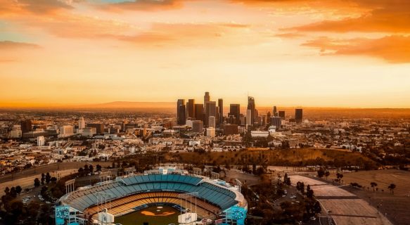
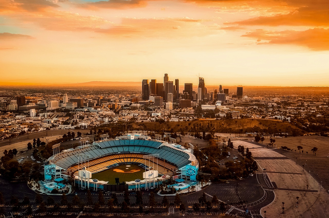
Sports

Los Angeles has great opportunities for seeing live pro sports. The Major League Baseball Los Angeles Dodgers are one of the most famous teams in baseball and a game at Dodger Stadium in Elysian Park, in the hills north of downtown, is an absolute treat for baseball fans. However, LA’s most successful sports franchise has been and remains the Los Angeles Lakers of the NBA, undoubtedly one of the greatest basketball teams in history. They play in the Staples Center in Downtown along with the less-famous Los Angeles Clippers of the NBA, who in recent years have risen from perennial losers to a competitive force. Also playing in the Staples Center are the Los Angeles Kings of the National Hockey League and the Los Angeles Sparks of the WNBA. The city’s Major League Soccer team, the LA Galaxy, plays at the StubHub Center in Carson. A second MLS team, Chivas USA, was folded by the league at the end of the 2014 season; the franchise rights were sold to a local group of investors, and the new team, Los Angeles FC, is expected to begin play in 2018.
The National Football League now has two teams in the L.A. area, both having returned to the area after having spent decades elsewhere. The Los Angeles Rams, which called L.A. home from 1946 to 1994 before moving to St. Louis, returned to L.A. in 2016. They currently play in the Los Angeles Memorial Coliseum in Exposition Park until their new stadium in Inglewood opens in 2020. The Los Angeles Chargers, which started their life in the old American Football League in 1960, moved to San Diego the next year and didn’t return until 2017. The Chargers will play at the StubHub Center in Carson before sharing the new Inglewood stadium with the Rams when it opens. For the second-largest city in the country, Los Angeles long showed an inexplicable inability to hold down a NFL franchise; during the Rams’ stint in St. Louis, Los Angeles football fans made do with the local college teams: the USC Trojans football team plays in the Coliseum, while the UCLA Bruins play in the Rose Bowl in Pasadena, which also hosts the annual famous college bowl game the stadium is named after.
In addition, Major League Baseball’s Los Angeles Angels and the National Hockey League’s Anaheim Ducks play in nearby Anaheim in Orange County.
Major college sports in L.A. aren’t limited to USC and UCLA, although those schools have by far the highest profiles since they’re the only two NCAA Division I schools in the area that play football. The immediate L.A. area boasts seven other Division I programs. The city of Los Angeles boasts the Cal State Northridge Matadors in the San Fernando Valley district of Northridge and the Loyola Marymount Lions in Westchester, while Los Angeles County also boasts the Pepperdine Waves in Malibu and the Long Beach State 49ers. Orange County is home to the Cal State Fullerton Titans and UC Irvine Anteaters, while the Inland Empire is home to the UC Riverside Highlanders. Also in Riverside are the California Baptist Lancers, which will join Division I in 2018.
Music

No matter what music you’re into, Los Angeles will feature artists to your taste, be it rock venues on Sunset Blvd, jazz clubs in Hollywood, or classic music in Downtown, just to scratch the surface. From the ambiance of the famous Hollywood Bowl to the spectacle of seeing a concert with 90,000 of your closest friends in the Rose Bowl in Pasadena, L.A. has many venues that are worth exploring.
Downtown Los Angeles holds several major entertainment venues. The 7,100 seat Microsoft Theater has become L.A.’s premiere venue for rock concerts and awards shows, while the nearby Staples Center, though primarily a sports venue, also hosts a large number of big-name concerts with its 19,000 seat capacity. Near the Civic Center, the Los Angeles Music Center consists of four music halls, most notably the Gehry-designed Walt Disney Concert Hall, home of the Los Angeles Philharmonic and Los Angeles Master Chorale, and the Dorothy Chandler Pavilion, home to the Los Angeles Opera.
Griffith Park holds the Greek Theatre, an outdoor amphitheater modeled after a Greek temple that hosts many concerts. Nearby Hollywood has two major concert venues in the Hollywood Palladium and the Fonda Theatre, the latter of which is reputed for its indie band scene and both of which regularly host big-name acts. A little further south, Wilshire has a couple of classic rock concert venues at the El Rey Theatre and The Wiltern. West Hollywood is home to some legendary rock nightclubs along the Sunset Strip, like Troubadour, Whisky a Go Go, and The Viper Room. Next to the USC campus and near Exposition Park in South Central L.A. is the Shrine Auditorium, a large enclosed amphitheater that holds over 6,000 people and regularly hosts large concerts and stage shows. In Inglewood, The Forum regularly hosts concerts as well as the occasional sports event.
Los Angeles also has an abundance of records stores scattered around the city, and though vinyl has disappeared from the shelves of most regular record stores, there are still plenty of stores that sell new and used vinyl. Amoeba Music in Hollywood is without a doubt the best in the city. An exploration of underground music would be advised to perhaps begin at The Smell in Downtown or listen to KXLU 88.9 FM Monday-Friday for details on numerous shows.
Theater

Los Angeles is a major center for stand-up and improvisational comedy, rivaling New York City given its proximity to the Hollywood industry and innovative scene; in recent years, L.A. has become the undisputed center for comedy podcasts. There are many excellent comedy venues in town, but a few consistently rise to the top. The Comedy Store is a legendary venue in West Hollywood on the Sunset Strip that gave rise to many of the biggest names in the 70s and still hosts the occasional nationally recognized comic. Also on the Sunset Strip is the Laugh Factory, which consistently features plenty of big-name comics. Elsewhere in West Hollywood you’ll find the Largo at the Coronet, a very popular venue that emphasizes the intersection between comedy and live music and regularly hosts podcast shows. Another renowned spot is the Upright Citizens Brigade in Hollywood, which has cultivated some of the best comics in the industry today and dominates L.A.’s improv and experimental comedy scene. Another pair of great improv venues are the Improv and The Groundlings, two popular clubs on Melrose Avenue in Fairfax.
Venues for stage productions abound in L.A., with the largest concentration being in Downtown. Along Broadway within Downtown’s Historic Core, the Theater District is full of old movie palaces that have been converted to performance spaces and concert halls. In Civic Center, the Ahmanson Theatre of the Los Angeles Music Center is the city’s main venue for plays, while the Music Center’s Mark Taper Forum is a prominent venue for experimental theater. The historic Pantages Theatre in Hollywood is the place to see Broadway musicals in town. Near the Hollywood Bowl is the Ford Theatre, a historic outdoor amphitheater that puts on community theater productions. Out in Westwood, the UCLA-affiliated Geffen Playhouse is noted for their original productions.
Events

Befitting its size, Los Angeles plays host to many major events throughout the year, from large conventions and spectacular holiday celebrations to more low-key neighborhood festivals. Whenever you come, you can be assured that something will be happening. What follows is just a sampling of the biggest annual events that take place in L.A.
Every January 1st, the New Year is rung in with the Tournament of Roses Parade, a massively popular parade in Pasadena with dozens of marching bands and elaborate floats before the famed Rose Bowl football game. Chinese New Year celebrations are held throughout the city in early February, with the biggest taking place in Chinatown with a dragon parade, live music, food, and firecrackers. March brings the L.A. Marathon, a massive event in which thousands of runners make their way from Dodger Stadium to Santa Monica. The popular Fiesta Broadway event takes place in Downtown on the last Sunday of April and is billed as the largest Cinco de Mayo celebration in the world, with lots of Mexican food, music, and pinatas.
Memorial Day weekend marks the start of summer, and is marked by a tribute at the Battleship USS Iowa in San Pedro. Summer brings many of the city’s biggest cultural festivals, such as Film Independent’s Los Angeles Film Festival in June, and Little Tokyo‘s Nisei Week Japanese Festival in mid-August. Summer also sees many major conventions and expositions, including the Electronic Entertainment Expo (E3) in June and Anime Expo in July, both of which are held at the Los Angeles Convention Center in Downtown. The Fourth of July is celebrated with lots of events across the city, most notably a spectacular fireworks show set to live music at the Hollywood Bowl.
In the fall, the Los Angeles County Fair takes place every September with concerts, carnival rides and agricultural exhibits in Pomona out in the San Gabriel Valley. Halloween brings lots of horror-themed events across the city, most notably the wildly popular West Hollywood Halloween Carnaval. After Thanksgiving, the holiday season kicks off with the Hollywood Christmas Parade, with plenty of elaborate floats, classic cars, and celebrity appearances. Other popular events during the holiday season include the Marina del Rey Holiday Boat Parade and a popular Christmas Eve music show in Downtown at the L.A. County Holiday Celebration.
Buy

Los Angeles has a well-known diversity of unique shopping destinations. Shopping malls will dominate your shopping experience in L.A. and even non-shopping visitors are likely to encounter them; for example, the Hollywood and Highland mall is a popular meeting point in Hollywood for those gazing at the Walk of Fame and Mann’s Chinese Theater, The Grove is a major destination in Fairfax next to the historic Farmer’s Market, and West Hollywood‘s Beverly Center is a massive eight-story shopping complex with a nice view of the city from its food court patio.
Lacking any significant public square, Los Angeles funnels its civic life onto its streets. Among the most popular shopping streets is Larchmont Blvd, which caters to the wealthy elite of Hancock Park with one-of-a-kind boutiques. Melrose Avenue in West Hollywood one-ups Larchmont Blvd with celebrity presence. And then there’s the fabled Rodeo Drive of Beverly Hills (uses the Spanish pronunciation: Roh-DAY-oh), famed for its high-end fashion stores.
In Downtown, the chaos of Broadway is a far cry from the comforts of manicured shopping centers, with merchandise geared towards the region’s Latino population. Here, beneath the street’s opulent early-20th century movie palaces, you can find a lot of brand name merchandise at discounted prices; forty dollars will probably get you a brand new wardrobe. Nearby is the gritty flea market of Santee Alley, chock full of knock-off designer labels and pirated DVD’s and CD’s. For a similar experience, try Alvarado Blvd between Wilshire and 6th in Westlake, where you can gain an insight into how most of working-class Los Angeles shops. Big deals can be found on a wide range of counterfeit goods, but don’t stay too long after dark when the neighborhood gets sketchy. Make sure to check out the Art Deco buildings that exist in between the makeshift warehouses as well as the Alvarado Terrace Park, surrounded by early-20th century mansions.
Downtown is also a destination for some specialized retail destinations. Want flowers? Why there’s a Flower District in Downtown! Jewelry? Fashion? Seafood? Toys? Yep, there are entire districts in Downtown dedicated to these particular products. You can buy art in Gallery Row up and down Main Street or see artists at work in the Arts District. All of these are located south and east of the towering Financial District, existing alongside the notorious Skid Row.
Eat

The Los Angeles area is one of the best places in the country for food – you can find just about anything you can imagine somewhere within its loose borders. From traditional American diner culture (try Mel’s Drive-In in West Hollywood) to the new wave of organic cafes, to inexpensive taco trucks, and swanky eateries with breath-taking food, there are no shortage of options.
Los Angeles abounds with inexpensive, authentic food that represents the culinary traditions of L.A.’s many immigrant communities. You have to be willing to do a little legwork, go to neighborhoods you might not otherwise go to and often deal with charmless fluorescent-lit storefronts in strip malls, but your reward is hype-free, authentic cuisine from around the world served up at bargain prices. Food critic Jonathan Gold has been finding and reviewing these gems since the 1980s, mostly for the free LA Weekly before he moved to the food section of the LA Times.
The newest arrival on the L.A. food scene is the gourmet food truck. These are not your average taco trucks and construction-site catering operations (although those exist too), but purveyors of creative and surprisingly high-quality food. Food trucks, particularly taco trucks, can be found in most parts of the city. A few noteworthy food trucks are “Grill Em All,” run by 2 metalheads doing outstanding gourmet hamburgers, “Nom Nom,” doing Vietnamese banh mi sandwiches, “Kogi,” doing Korean-inspired tacos and burritos, and “Manila Machine,” doing Filipino food. Many trucks also have their own websites and post their daily schedules and locations on Twitter.
On the opposite spectrum from food trucks, those seeking high-end dining have some of the country’s finest restaurants to choose from. While the Michelin guide stopped reviewing Los Angeles in 2010, Beverly Hills had several eateries that were rated by Michelin, including Wolfgang Puck’s first restaurant, Spago. While there are numerous destinations for an upscale meal throughout the LA area, Santa Monica is notable as the only city besides Beverly Hills that can lay claim to multiple Michelin starred restaurants.
Coverage of regional food from other parts of the U.S. is spotty. Migration into the city has been disproportionately from Texas and Oklahoma, the South, Midwest and greater New York City and food representing these areas is easy enough to find. Food representing New England and other parts of the East Coast, the Pacific Northwest, and the Intermountain-Rocky Mountain regions can be elusive, along with many ethnic cuisines with central- and east-European origins. However L.A. is birthplace of the drive-thru and numerous fast food chains clog the roadsides. The In-N-Out Burger chain is far above average for hamburgers, french fries and milkshakes. Another famous Los Angeles establishment is Original Tommy’s, which specializes in chili burgers.
The cultural diversity of Los Angeles is an evident influence on the local vegetarian food restaurant industry. You can find strictly vegan and vegetarian dining, be it American, Mexican, Chinese, Ethiopian, and Thai among others. Other dietary restrictions are catered to as well. For example Genghis Cohen in West Hollywood serves Jewish Chinese food and kosher Mexican or Italian is not hard to find along predominantly Jewish parts of Pico Boulevard.
There are several different supermarket chains of varying quality – for something different (and cheap) try Trader Joe’s, a reputable grocery store with multiple locations (the original is in Pasadena), selling many organic products with no preservatives. They normally give out great samples to the public and sell their acclaimed Charles Shaw wine, also known as “Two Buck Chuck.” Whole Foods is another market with multiple locations and a favorite among the health conscious — but also a little pricey. Their salad bar is fully stocked, they have huge fresh burritos, sushi, hot dishes ready to go, and a comprehensive selections of pre-made, delicious salads.
LA visitors and locals alike have the opportunity to indulge in a selection of specially priced three-course menus from a wide variety of LA’s best restaurants during dineLA Restaurant Week.
Drink
Hotel bars are generally considered by Angelenos to be the nicest places to have drinks. Some of the more popular upscale ones include Chateau Marmont, Skybar at The Mondrian, and Tower Bar at the Sunset Tower on the Sunset Strip in West Hollywood, and The Rooftop Bar at The Standard in Downtown LA. Hollywood and the Sunset Strip are generally considered the nightlife centers of LA, though neighborhoods such as Silver Lake, Los Feliz, and Echo Park in Northwest LA are home to the dive bars and cafes favored by trendy hipsters. Downtown has recently recaptured some of its former glory with a selection of popular nightlife destinations such as The Golden Gopher, The Edison and the bars/clubs at LA Live. Hollywood’s Cahuenga Corridor (Cahuenga between Selma and Hollywood Boulevard) boasts several popular bars in a row, making bar-hopping a possibility in a city where it’s not the norm.
Bars close at 2AM with most last calls at 1:30 or 1:45. It is worth noting that some bars and almost all clubs charge cover and some may have VIP lists that are relatively easy to get on. Look up promoters and ask them to add you to their list. This is the easiest way to get into many of the popular Hollywood clubs.
Sleep
It’s hard to summarize the plethora of hotel options in L.A. From some of the most opulent (and expensive) hotels in the world to budget hostels to apartment-hotel crash pads, there’s something for everyone. Deciding where to stay will have a lot to do with what areas you plan on visiting, and how you’re going to get there. As usual in Southern California, a car opens up a world of options, but be sure to check the parking arrangement at your accommodations before you arrive.
Hollywood and the Sunset Strip are probably the most popular options for those wanting to sight-see and chase their image of that world. Downtown has long been popular with the business crowd but is rapidly receiving a makeover with newer hotels drawing a hipper crowd. Beverly Hills has some of the nicest hotels in the city, and one should expect the prices to reflect its reputation. Sun and sand seekers can head to Santa Monica or Venice, while those just in town for a day or two might consider staying in one of the suburbs near LAX. To the northeast of Downtown L.A., Pasadena is a peaceful and leafy city and a good alternative that’s still proximate to many major attractions, while Burbank has many places convenient to the Valley. Long Beach offers plenty of cheaper accommodations on the south side of the city.
Connect
Internet
Internet cafes are spread around town and most easily found in heavily touristed spots such as Hollywood Blvd and Melrose Ave. For most travelers, stopping by a local coffee shop such as Starbucks or The Coffee Bean & Tea Leaf should suffice. Most will either have free service for customers or require a nominal fee for usage. Many less expensive hotels and motels also offer complimentary internet access, often usable in the lobby before you check in.
There is also a growing trend for local fast food establishments and some restaurants to provide complimentary Wi-Fi.
Stay safe
For emergencies in Los Angeles County, dial 911 toll-free from any phone including payphones. Note that dialing 911 from a cellphone will place you in contact with the California Highway Patrol.
Most tourist destinations within Los Angeles area tend to be fairly safe, including Hollywood, Beverly Hills, Santa Monica, Westwood, and West L.A. However, walking at night in some areas of the city (and some suburban cities as well) should be conducted with caution; and depending on the area, in groups. If traveling by car there is little threat of being harassed day or night, provided you avoid driving around neighborhoods with blatant signs of gang activity as mentioned below.
Certain areas in or near downtown, such as Skid Row (which is where the Greyhound station is located), Pico-Union, Westlake, Boyle Heights, South Central, Compton, Inglewood, Harbor Gateway, and Wilmington can be dangerous regardless of the time of day and should be avoided altogether when walking if possible. If traveling in the San Fernando Valley region of Los Angeles, the neighborhoods of Pacoima, Panorama City, Van Nuys, North Hills, and Canoga Park are also best avoided on foot.
Though cities such as Detroit, St. Louis, and Atlanta have higher reported crime rates per capita than Los Angeles, these numbers can be deceiving. L.A. statistics are skewed because safe neighborhoods such as Bel Air, Pacific Palisades and Westwood help balance the numbers from the very dangerous neighborhoods. If the South Central area of Los Angeles were counted as its own city, it would have the highest crime and murder rate of any city in America. Neighboring Compton, an actual independent city, currently ranks as the fourth most dangerous city in America. Luckily for Los Angeles, Compton’s statistics are not counted as part of L.A.’s crime data, but the cities border each other. As a general rule, you should exercise great caution if walking in the area roughly bounded by Interstate 10 on the north, Interstate 710 on the east, Artesia Blvd/Highway 91 on the south, and La Cienega Boulevard on the west. East LA also has a higher crime rate than other areas and has gang problems as well.
Both the City of Los Angeles and the County of Los Angeles, unfortunately, are considered the gang capital of America. Gangs generally confine themselves to certain areas and should be of little concern to the typical traveler, who is unlikely to venture into such areas. Gangs will usually identify their territory with graffiti markings. While most visitors to L.A. will not visit neighborhoods where gang violence is a concern, common-sense precautions apply should you become lost and end up in a bad neighborhood: remain on high-visibility roads or freeways, avoid confrontations with groups of young men, and should a confrontation arise flee immediately. If a person who appears to be a gang member asks you where you are from, prepare to flee or to defend yourself, as that is a common gang challenge. Use common sense on freeways to avoid incidents of road rage, which accounts for ten or so deaths per year.
Most homeless individuals are harmless; they will likely only ask you for money and if you refuse, will simply go on to the next person. They are most heavily concentrated in Hollywood, Skid Row, and Venice Beach. Avoid walking along Skid Row near Downtown at any time of day or night.
Minor earthquakes happen occasionally but they’re almost always harmless. In the unlikely event of a major earthquake: If you’re outside, try to find an open space clear of anything that might fall on you, such as trees, power lines, street lights or buildings. If you’re inside, try to shield yourself under a table or desk from falling debris; your biggest threat comes from breaking windows and falling objects such as ceiling tiles and bookshelves, so try to reduce your exposure to these threats. If you can’t find a table or similar protection, at the very least cover your head and neck with your arms. You are more likely to be injured if you try to run or stand during a quake, so drop to your hands and knees and crawl if you need to move. If you’re driving, stop your car and move out of traffic, and stay in your car in a place clear of trees, power lines, street lights, and over- or underpasses. Since the 1950s, buildings have become progressively stronger with stricter building code regulations and research, and most buildings built after 1978 are in no danger of collapsing in the unlikely event of a major earthquake during your visit.
Stay healthy
Los Angeles is notorious for air pollution problems. However, air quality in the city has improved dramatically in recent decades, and Los Angeles has even fallen from its Number One position on lists of the worst air in the United States due to aggressive cleanup efforts on behalf of the state and regional air quality authorities. Generally, smog is worst during summer months and is worse further inland where it is away from the ocean breezes and gets trapped by the surrounding mountains. “Smog Alert” days are at an all-time low, but air pollution can still become a problem if a wildfire is burning in surrounding hills. For more information, visit the AQMD (Air Quality Management District) website for air quality information in the region.
Cope
Newspapers
Los Angeles’ primary newspaper is the Los Angeles Times, and another daily newspaper is the Los Angeles Daily News. The free LA Weekly comes out on Thursdays and is a good source for concerts, movies, and other local information. A few local areas may have their own free neighborhood papers as well.
Gyms
- 24 Hour Fitness and LA Fitness (which now includes Ballys) have many locations throughout the area and are big here. If you have a regular membership with either of them from back home your membership is good here. Note that some memberships are only good for one location and will cost extra to access a different gym/club than the one normally go to at home. Ask before leaving home. Otherwise day passes range from $10-$20. Bring a lock and towel.
Consulates
Los Angeles is home to many people of different nationalities and language backgrounds. Therefore, many countries have established full service consulates (Consulates Generals) in Los Angeles to provide consular services for their nationals living in (southern) California and in the adjacent states in the southwestern part of the U.S. (or the entire west coast) as well as visa services for others seeking to visit their respective countries (if required). The Honorary Consulates are there for commercial and business purposes and offer limited or no consular services except in emergency situations. Most of the consulates are located along Wilshire Blvd in/around the Wilshire neighborhood and West Los Angeles, between downtown and Santa Monica. They can also be located in other parts of town too:
 Argentina, 5055 Wilshire Blvd Ste 210, ☎ +1 323 954-9155, fax: +1 323 934-9076.
 Armenia, 346 N. Central Avenue, Glendale, ☎ +1 818 265-5900, fax: +1 818-265-3800, e-mail: office@armeniaconsulate.org.
 Australia, 2029 Century Park E, Century Plaza Towers 31F, ☎ +1 310 229-2300, fax: +1 310-229-2380, e-mail: losangeles@dfat.gov.au.
 Austria, 11859 Wilshire Blvd, Suite 501, ☎ +1 310 444-9310, fax: +1 310-229-2380, e-mail: los-angeles-gk@bmeia.gv.at.
 Bangladesh, 4201 Wilshire Boulevard, Suite 605, ☎ +1 323 932-0100, fax: +1 323 932-9703, e-mail: info@bangladeshconsulatela.com.
 Belgium, 6100 Wilshire Blvd Ste 1200, ☎ +1 323 857-1244, fax: +1 323 936-2564, e-mail: LosAngeles@diplobel.fed.be.
 Bolivia, 3701 Wilshire Blvd, Suite 1065, ☎ +1 213 388-0475, fax: +1 213-384-6274, e-mail: cbolivia@sbcglobal.net.
 Brazil, 8484 Wilshire Blvd Ste 711/730, Beverly Hills, ☎ +1 323 651-2664, fax: +1 323-651-1274, e-mail: comunicacoes@brazilian-consulate.org.
 Canada, 550 South Hope St 9F, ☎ +1 213 346-2700, fax: +1 213 620-8827, e-mail: lngls@international.gc.ca.
 Chile, 6100 Wilshire Blvd Ste 1240, ☎ +1 323 933-3697, fax: +1 323-933-3842, e-mail: cgchilela@yahoo.com.
 China, 443 Shatto Pl, ☎ +1 213 807-8088, fax: +1 213-807-8091.
 Colombia, 8383 Wilshire Blvd, Suite 420, Beverly Hills, ☎ +1 323 653-4299, fax: +1 323-653-2964.
 Costa Rica, 1605 W. Olympic Blvd, ☎ +1 213 380-7915, fax: +1 213-380-5639, e-mail: costaricaconsulatela@hotmail.com.
 Denmark (Honorary), 5849 Uplander Way, Culver City, ☎ +1 310 645-0540, fax: +1 310 645-0560, e-mail: info@danishconsulate.org.
 Dominican Republic, 500 N. Brand Blvd, Glendale, ☎ +1 818 504-6605, fax: +1 818 504-6617, e-mail: consuladord@gmail.com.
 Ecuador, 8484 Wilshire Blvd Ste 540, Beverly Hills, ☎ +1 323 658-6020, fax: +1 323-658-1198, e-mail: ceculosangeles@mmrree.gov.ec.
 El Salvador, 3450 Wilshire Blvd, Suite 250, ☎ +1 213 234-9200, e-mail: consuladoesla@rree.gob.sv.
 Finland, 1801 Century Park East, Suite 2100, ☎ +1-310-203 9903, fax: +1-310-203 9186, e-mail: sanomat.los@formin.fi. M-Th 8:30AM-5PM, F 8:30AM-2PM.
 France, 10390 Santa Monica Blvd, Ste 115 & 410, ☎ +1 310 235-3200, fax: +1 310 479-4813.
 Germany, 6222 Wilshire Blvd Ste 500, ☎ +1 323 930-2703, fax: +1 323-930-2805.
 Greece, 12424 Wilshire Blvd Ste 800, ☎ +1 310 826-5555, fax: +1 310-826-8670, e-mail: lagr@greekembassy.org.
 Guatemala, 3540 Wilshire Blvd, Suite 100, ☎ +1 213 365-9251, fax: +1 213-365-9245.
 Honduras, 3550 Wilshire Blvd, Suite 320, ☎ +1 213 995-6409, fax: +1 213-995-6407, e-mail: cghonduras.losangeles@yahoo.com.
 Indonesia, 3457 Wilshire Blvd, 4th floor, ☎ +1 213 383-5126, fax: +1 213-487-3971, e-mail: kjri@kjri-la.net.
 Ireland (Honorary), 751 Seadrift Dr, Huntington Beach (40 mi S of L.A. off I-405), ☎ +1 714 658-9832, fax: +1 714-374-8972, e-mail: icla@ireland.com.
 Israel, 11766 Wilshire Blvd Ste 1600, ☎ +1 323 852-5500, fax: +1 323-852-5500, e-mail: info@losangeles.mfa.gov.il.
 Italy, 12400 Wilshire Blvd Ste 300, ☎ +1 310 820-0622, fax: +1 310 820-0727, e-mail: progettispeciali.losangele@esteri.it.
 Japan, 350 S Grand Ave Ste 1700, ☎ +1 213 617-6700, fax: +1 213-617-6727, e-mail: ikenbako@la-cgjapan.org.
 Korea, Republic of, 3423 Wilshire Blvd, ☎ +1 213 385-9300, +1 213 700-1147 (emergencies), fax: +1 213 385-1849. Mon-Fri 09:00-17:30 (Civil Services close at 16:00).
 Kenya, 4801 Wilshire Blvd, Park Mile Plaza, Mezzanine Floor, ☎ +1 323 939-2408, fax: +1 323-939-2412.
 Mexico, 2401 W 6th St, ☎ +1 213 351-6800, fax: +1 213 389-9186.
 Netherlands (Honorary), 11766 Wilshire Blvd Ste 1150, toll-free: +1 877-DUTCHHELP (388244357), fax: +1 310-478-3428, e-mail: nclosangeles@gmail.com.
 New Zealand, 2425 Olympic Blvd, Suite 600E, Santa Monica CA 90404, ☎ +1 310 566-6555, fax: +1 310 566-6556.
 Pakistan, 10700 Santa Monica Blvd, Suite 211, ☎ +1 310 441-5114, +1 323 470-2000 (emergencies). Mon-Fri 09:00-13:00 & 14:00-17:00.
 Philippines, 3600 Wilshire Blvd Ste 500, ☎ +1 213 639-0980, fax: +1 213-639-0990, e-mail: losangelespcg@earthlink.net.
 Portugal (Honorary), 1801 Avenue of the Stars Ste 400, ☎ +1 305 444-7649.
 South Africa, 6300 Wilshire Blvd Ste 600, ☎ +1 323 651-0902, fax: +1 323-651-5969, e-mail: info.losangeles@foreign.gov.za.
 Spain, 5055 Wilshire Blvd Ste 860, ☎ +1 323 938-0158, +1 323-938-0166, fax: +1 323-938-2502, e-mail: cog.losangeles@maec.es.
 Sweden, 10940 Wilshire Boulevard Suite 700, ☎ +1 310 445-4008, fax: +1 310-473-2229, e-mail: ConsularinfoLA@foreign.ministry.se.
 Switzerland, 11766 Wilshire Blvd Ste 1400, ☎ +1 310 575-1145, fax: +1 310 575-1982, e-mail: los.vertretung@eda.admin.ch.
 Taiwan (Taipei Economic and Cultural Office), 3731 Wilshire Blvd Suite 700, ☎ +1 213 389-1215, +1 213 923-3591 (emergencies 急難救助). Mon-Fri 09:00-16:30.
  United Kingdom, 11766 Wilshire Blvd Ste 1200, ☎ +1 310 481-0031, fax: +1 310 481-2960.
Some of the countries maintain a consulate in both San Francisco and Los Angeles while others have a consulate in one city or the other.
Go next
- Orange County — many upscale communities, some along the ocean, southeast of Los Angeles. Home to Disneyland and Knott’s Berry Farm among other attractions.
- Palm Springs — Desert playground of the rich and famous.
- Joshua Tree National Park — Two different deserts meet in this park, which is filled with a vast array of rock formations and desert plant life, especially in the spring or after rainfall when the desert flowers are in bloom.
- Santa Barbara — A quiet seaside resort town a 1 1/2 hour drive north of Los Angeles.
- San Diego — A sunny oceanfront city with many attractions such as Sea World, the San Diego Zoo and the museums of Balboa Park, approximately a 2-hour drive south of Los Angeles (depending on traffic).
- Las Vegas — a major metropolitan area in the Mojave Desert, approximately a 4 1/2 hour drive northeast of Los Angeles. It is known for its entertainment, casinos, shopping, and restaurants. The I-15 North freeway in adjoining Riverside and San Bernardino Counties goes directly to Vegas.
- Baja California — whether it’s to experience the high energy of Tijuana, the beach town of Rosarito, or the fabulous local wine in the port city of Ensenada, the joys of Mexico are only a 2 1/2 hour drive away.
| Routes through Los Angeles |
| Santa Barbara ← Glendale ← | N |
→ Fullerton → San Diego |
| END ← | W |
→ Fullerton → Albuquerque |
| END ← | W |
→ Pomona → Tucson |
| Sacramento ← The Grapevine ← | N |
→ Buena Park → Santa Ana |
| Ends at |
W |
→ Upland → San Bernardino |
| Santa Barbara ← Agoura Hills ← | N |
→ END |
| END ← | W |
→ Chino → Riverside |
Top Tips for Visiting Los Angeles