The centerpiece of the Bay Area, San Francisco is one of the most visited cities in the world, and with good reason. The cultural center of northern California, San Francisco is renowned for its mixture of scenic beauty and unique culture that makes it one of the most vibrant and desirable cities in the nation, if not the world.
Sandwiched between the San Francisco Bay and the Pacific Ocean on a small square of land seven miles (11 km) on each side, San Francisco offers a wealth of treasures for the visitor, from the windswept and often foggy bay to the steep hills lined with Victorian homes that overlook the spectacular scenery of the city. Great ethnic and cultural diversity shows itself in the city’s varied neighborhoods, from the crowded and exciting streets of Chinatown to the eclectic attitudes of the Castro and the gleaming condominium towers built on the city’s more recently gained tech-savvy reputation.
And yet San Francisco is just one of the cities which makes up the entire San Francisco Bay Area. At the center of a metropolitan area of 7.6 million people, the city is a fantastic base to explore the treasures of San Francisco’s neighbors to the east across the Bay Bridge, to the north past the Golden Gate Bridge, and to the south down the peninsula. There’s enough to see that one could devote a lifetime to exploring the region, and it’ll become clear why people continue to make their way to this special place.
Districts
Each district of San Francisco carries its own unique and distinct culture. This map is predominantly based on the 11 official governmental districts of San Francisco, but it has been adapted to suit the purposes of this travel guide. Some districts of particular interest to travelers have been broken up into popular neighborhood groupings, while others, mainly residential districts, have been merged.

| Golden Gate Fashionable neighborhoods, e.g., the Marina District, Cow Hollow, and Pacific Heights, with extensive views and historical landmarks — Fort Mason, The Presidio, and the iconic Golden Gate Bridge. |
| Fisherman’s Wharf A touristy waterfront neighborhood which encompasses Ghirardelli Square, Pier 39, and the ferry launch to Alcatraz Island, as well as a plethora of seafood restaurants and souvenir stores. |
| Nob Hill-Russian Hill Two ritzy neighborhoods with upscale hotels, cable cars, panoramic views and steep inclines. |
| Chinatown-North Beach Two vibrant immigrant communities; the crowded and largest Chinatown outside of Asia next to the stylish laid back ‘Little Italy’, as well as Telegraph Hill and Coit Tower. |
| Union Square-Financial District Union Square is the center of shopping, theater and art in the city, next to the many skyscrapers of downtown and Market Street. |
| Civic Center-Tenderloin The neoclassical Civic Center next to the grit of the Tenderloin. While the ‘Loin’ is grittier compared to its ritzier neighbors downtown, there is still plenty of interesting architecture and attractions to see here. |
| SoMa (South of Market) A rapidly changing neighborhood of downtown that is the center of a lot of new construction, including new skyscrapers, some of the city’s newest museums, and AT&T Park, home of the San Francisco Giants. |
| Western Addition A historic neighborhood with many Victorian homes that was once a hotbed of African-American culture. Within the area is also Japantown, once the center of San Francisco’s Japanese population, still populated with many Japanese stores and restaurants, and hotels that cater to Japanese travelers. |
| Haight Famous for being the home of the Hippie movement, this once bohemian area is still an eclectic treasure. |
| The Avenues Includes both the foggy Sunset and Richmond Districts, separated by the scenic and lush Golden Gate Park and bounded on the west by Ocean Beach. |
| Twin Peaks-Lake Merced Covering most of southwestern San Francisco, this area is home to many of the taller hills of San Francisco and the large Lake Merced park, which contains the San Francisco Zoo. |
| Castro-Noe Valley Colorful and cohesive, the Castro is historically known for being the cultural center of the city’s LGBTQ community. Nearby Noe Valley offers excellent restaurants and shops along pleasantly walkable streets. |
| Mission This vibrant area is home to a large Hispanic community as well as new urban artisans, and is a center of San Francisco night life. For visitors wishing to get off the beaten tourist paths and catch some local flavor, this is the place to go. |
| Bernal Heights A charming neighborhood atop a hill on the southern side of the city and a cultural center for San Francisco’s lesbian community. |
| Southeast San Francisco A mostly lower income residential area, this district contains several bay-side neighborhoods and many nice parks. |
Understand
History
Prior to European settlement in the area, the peninsula that now contains San Francisco was home to the Yelamu tribe, who were part of the larger Ohlone language group which stretched south from the Bay Area to the Big Sur of California. Due to San Francisco’s characteristic foggy weather, the earliest European explorers completely bypassed what would later be called the Golden Gate and the San Francisco Bay. The first European settlement in the area was founded by the Spanish in 1776 as a mission community surrounding the Mission San Francisco de Asís, in what is today called the Mission Dolores in the Mission District. In addition to the mission, a military fort was built near the Golden Gate: El Presidio.
Upon gaining independence from Spain in 1821, the area became part of Mexico. Under Mexican rule, the mission system gradually came to an end and private ownership of land became a possibility. In 1835, an Englishman named William Richardson founded the town of Yerba Buena, the first significant settlement on the peninsula outside of the Mission Dolores area. As the new settlement gradually grew, Yerba Buena developed a street plan and became attractive to settlers. Following the Mexican-American War the United States claimed California, and in July of 1846 the U.S. Navy arrived to raise the American flag above Yerba Buena. Over the next couple of years, California officially became part of the United States and the name of the town was changed from Yerba Buena to San Francisco.
In 1848 the California Gold Rush started in the Sierra Nevada mountains. Prior to the opening of the Transcontinental Railroad, getting to San Francisco involved an arduous overland journey or a lengthy voyage by sea, but that didn’t stop waves of fortune-seeking immigrants from making the trip, increasing the city’s population from a few thousand to hundreds of thousands. Many who made their fortunes then settled in San Francisco, which at the time was the largest, most exciting city in California. Like other large cities, eventually San Francisco developed into districts by nationality or social status: the Italians in North Beach, the Chinese in Chinatown, and the wealthy mining and railroad titans on Nob Hill. During the gold rush years many major businesses were created and flourished in San Francisco (Wells Fargo Bank, Levis, Bank of America), and famous and infamous personalities alike settled in the city. Of course, with all this success came problems: the rapid growth of the city outstripped any efforts at city planning, meaning proper sanitation and infrastructure were largely undeveloped, which led to a cholera outbreak in 1855. Violence and corruption were evident, and anti-immigrant violence resulted in many race riots.
|
Emperor Norton  In 1859 one Joshua Abraham Norton, who had been a wealthy businessman prior to losing his fortune on Peruvian rice, proclaimed himself “Norton I, Emperor of the United States” and later “Protector of Mexico”. While he was widely seen as eccentric, he was quite popular among many inhabitants of San Francisco due to his “decrees” calling for the dissolution of Congress or the construction of bridges or tunnels to cross San Francisco Bay. One of his more eccentric (though widely popular) edicts was banning use of the word “Frisco” (then as now a common shorthand for the city hated by its residents) and imposing a $25 penalty on its use. While Norton did not ever have any real authority he was beloved by many of San Francisco’s inhabitants and inspired many books and newspaper articles both during and after his lifetime. When he died in 1880, some 10 000 people attended his funeral. |
In the 1890s, there was a large campaign to modernize and beautify the city, the success of which led some officials to proudly call San Francisco the “Paris of the West.” But in 1906, a devastating earthquake shook the city and a resulting fire leveled much of the city (in fact, almost 90% of the total damage was from the fire, and not the quake itself). Nevertheless, officials at the time immediately set out on a plan to rebuild the city, with new parks, boulevards, the current civic center complex, and landmarks such as the Coit Tower atop Telegraph Hill. In 1915, San Francisco hosted the Panama-Pacific Exposition (where the Palace of Fine Arts complex is currently located) to showcase the completely rebuilt city.
In the wake of the Great Depression of the 1930s, San Francisco remained largely unscathed. In fact, it was during this time that the Golden Gate Bridge and the Bay Bridge were conceived and built. It was also during this time that the federal government established a prison on Alcatraz Island, which would hold some of the most notorious criminals of the era.
After World War II, San Francisco continued to grow in population. Aggressive urban planning projects led to a changing skyline, with more highrises in the city’s financial district and new freeways rimming the city’s waterfront. But in some sense the years after World War II were also unique in what didn’t happen; while cable cars were once commonplace throughout North America, San Francisco remains the last place to still have them in daily use as actual transportation. Sprawl and auto-centric development have also happened in San Francisco, but less so than in most other American cities and it is therefore still one of the best destinations to explore the United States without a car. In later years, the waterfront freeways were deemed an eyesore and eventually torn down and replaced with the far more pleasant Embarcadero Boulevard.
Besides being a beautiful city to visit, from the 1950s forward San Francisco became known as the city of the cool, quirky, unusual, and counterculture. There were the Beatniks of the fifties and sixties, and the hippies in the sixties and seventies. “Only in San Francisco” became part of the lexicon to describe San Francisco’s counterculture and rebel population, a reputation that still exists today. The film industry also made San Francisco world-famous and instantly recognizable; the city provides a superb backdrop for a movie, regardless of genre or topic.
Since 2000, San Francisco has experienced a development boom. Even with the burst of the dot-com bubble, the economy has remained robust and the city government pushed for redevelopment of its blighted industrial section known as “South of Market”. Today, the SoMa area is crowded with new condominium and office buildings, new tourist attractions, and dot-com industries. The city’s efforts have shielded it somewhat from the recent recession and subsequent real estate crash, and today the financial sector is second only to tourism as San Francisco’s largest industry, with the city consistently remaining at the top five of the world’s most popular tourist destinations.
Climate
-
-
- “The coldest winter I ever spent was a summer in San Francisco.” — attributed to Mark Twain
-
| Climate | Jan | Feb | Mar | Apr | May | Jun | Jul | Aug | Sep | Oct | Nov | Dec |
|---|---|---|---|---|---|---|---|---|---|---|---|---|
| Daily highs (°F) | 56 | 60 | 61 | 63 | 64 | 66 | 66 | 66 | 70 | 69 | 64 | 57 |
| Nightly lows (°F) | 46 | 48 | 49 | 50 | 51 | 53 | 54 | 54 | 56 | 55 | 51 | 47 |
| Precipitation (in) | 4.1 | 3.5 | 2.9 | 1.5 | 0.5 | 0.2 | 0 | 0 | 0.2 | 1.1 | 2.6 | 3.9 |
The best time to visit San Francisco is late September through October, when it is relatively the warmest. All year long, it never gets too cold for winter clothing, and it rarely gets warm enough for shorts and sandals. You will typically need a sweater after sunset, and a windbreaker if you’re out by the western part of the peninsula. Prepare to dress in layers to adequately face the microclimates described below.
San Francisco has a mild climate, with cool, wet winters and dry summers. In most months, you can expect the high temperature to be in the upper 50s, 60s or low 70s degrees Fahrenheit (between 15 and 25 degrees Celsius). However, these mild temperature readings belie a unique climate not shared by other major cities in the state or country.
Summer days usually start out under fog, slowly burning off towards the ocean into a sunny albeit windy afternoon. Measureable precipitation during the summer months is rare, although light drizzle is possible. Humidity is very constant, but rarely uncomfortable. At late afternoon, when the fog and wind returns people generally find themselves needing a jacket (and this is summer!). There are some days when the fog lingers all day.
In the winter, the rainy season is in full swing. That being said, the chances for a calm, windless, sunny day are actually higher in the winter than in the summer! However, the overall temperatures are going to be lower in the winter.
Spring and fall are not so much seasons in themselves in San Francisco, but rather they are quick transitional periods with some days resembling summer and others the winter. Fall in particular is a good time to visit because the summer wind & fog has mostly gone, but the rainy season has not yet started. The late summer month of September, as summer transitions into fall, is the warmest and driest month of the entire year for San Francisco. Heat waves can occasionally occur around this time of year.
Within these general rules, San Francisco also has a series of microclimates created by the city’s topography and maritime setting. Large hills in the city’s center block much of the fog, wind, and precipitation that rolls in from the Pacific Ocean. Because of this, there can be significant weather differences in different parts of the city and the surrounding Bay Area at the same time. Generally, the more windward areas along the coast (e.g., the Outer Sunset) are cooler and foggier, while the more leeward areas in the east are warmer and drier (e.g., the Mission). Temperature differences of 10-15 degrees or so are common on days where the fog persists on the western side of the city. These differences continue as you move east, out of the city, into the East bay, and into the outer East Bay (on the other side of the hills from Berkeley and Oakland), where it can be much hotter and drier. Local meteorologists routinely have three forecasts: one for the coast, one for the bay, and one for the inland areas. In short, if you don’t like the weather, perhaps travel a few miles east or west to your desired climate.
Architecture

San Francisco is known for its Victorian architecture, particularly in the central and northern neighborhoods (e.g., Haight-Ashbury, Alamo Square, Noe Valley, Castro, Nob Hill, and Pacific Heights). The city has one of the most restrictive building and planning codes in the world, which helps preserve the historical architecture in certain areas and create a severe shortage of housing stock, which drives up the price of housing. The exorbitant price of housing, both buying and renting, is a favorite topic of San Francisco locals. It helps to explain why there are so few families in San Francisco (another favorite topic).
In recent years, San Francisco has undergone high-rise construction boom centered in SoMa, just south of what was historically the center of downtown. This was one of the few areas of the city left for development (i.e. without entrenched anti-development policies). Unlike other major cities like New York and Chicago, San Francisco is not known for having buildings built by star architects. This may be due to the difficulty of getting projects approved in the city.
Culture
San Francisco prides itself on its openness to diversity in race, gender, sexual orientation and personal style. This trait is widely considered to be one of the defining features of the city, and it draws both visitors and transplants alike.
English is the dominant language spoken in San Francisco. San Francisco is home to the second largest Chinese community in the United States after New York City, and Cantonese is commonly spoken in the various Chinese-dominated neighborhoods, with an increasing Mandarin-speaking minority. Like much of California, there is also a large Latin American population, so Spanish is also commonly spoken in San Francisco, especially in the Mission District. In addition, there is also a large Filipino community, and Tagalog is commonly heard in Filipino neighborhoods. Most municipal government services are available in English, Cantonese, Spanish and Tagalog.
Tobacco smokers beware: as in the rest of California, smoking is illegal in bars, restaurants, and other public places. Additionally, the City of San Francisco has a local ordinance that require smokers to go all the way to the curb (or if there is no curb, at least 25 feet from any building – not simply the entrances). As of January 2013 enforcement is inconsistent and the odds you’ll be hassled for standing and smoking outside a restaurant or bar are low. Bay Area people can be particularly vocal about personal habits, so take care and be mindful and respectful of others when smoking, even in places where it is allowed.
On the other hand, smoking marijuana is remarkably well-tolerated. While still illegal under federal law, California law allows for the possession, use, and cultivation of small amounts of marijuana for adults 21 and over. Using marijuana in public is technically illegal, so you shouldn’t smoke marijuana just anywhere, but the rules of etiquette are difficult to navigate. You might find people smoking marijuana at large concerts, but not small concerts, or people smoking marijuana on a street corner in the middle of the day in some neighborhoods (e.g., Haight-Ashbury) but frowned upon in others (e.g., the Financial District).
Public nudity has been celebrated among some residents in recent decades. More recently, however, there has been some controversy surrounding public nudity in San Francisco. There is now a law banning some public nudity, with nudists actively opposing the law.
It’s worth mentioning that natives tend to dislike many of the nicknames given to their city. Instead of saying “San Fran,” “Frisco,” or “SFO,” most refer to San Francisco by its full name or just “The City.”
The Bay Area has of one the most vibrant high-tech startup scenes in the world. While the venture capital firms are largely in the South Bay, many of the small startups and tech workers are in San Francisco.
Tourist information
San Francisco’s visitor information centers offer maps, brochures and other information for tourists.
- San Francisco Visitor Information Center, 900 Market St (next to the cable car turnaround at Market & Powell, near Union Square), ☎ +1-415-391-2000, fax: +1-415-362-7323. May through October: M-F 9AM-5PM, Sa-Su and holidays 9AM-3PM. November through April: M-F 9AM-5PM, Sa and holidays 9AM-3PM. Closed Easter, Thanksgiving Day, Christmas Day, and New Year’s Day. Visitor Center run by the San Francisco Convention & Visitors Bureau.
- California Welcome Center, Fisherman’s Wharf, Pier 39, Building P, Second Level, ☎ +1-415-981-1280, e-mail: info@pier39.com. One of several California Welcome Centers across the state.
Get in

By plane
- San Francisco International Airport, +1-800-435-9736 (SFO IATA) located about 10 mi (16 km) south of the city, is the Bay Area’s major international airport (and one of the busiest in the nation) and has numerous passenger amenities including a wide range of food and drink establishments, shopping, baggage storage, public showers, a medical clinic, and assistance for lost or stranded travelers and military personnel. SFO has four terminals; as a rule of thumb, Virgin America and American Airlines use Terminal 2, United Airlines has Terminal 3, all other domestic carriers use Terminal 1, and all international flights use the International Terminal.
- Oakland International Airport, +1-510-563-3300 (OAK IATA) in the East Bay provides service to numerous destinations in the United States as well as Mexico. Oakland is primarily used by low-cost carriers, and is a major hub for Southwest Airlines.
- Norman Y. Mineta San Jose International Airport, +1-408-277-4759 (SJC IATA) in Silicon Valley about 1 hour south of San Francisco, attracts Bay Area residents who find SFO to be inconveniently distant from their homes. Southwest Airlines is the dominant carrier here as well, and while Alaska and Volaris service nearby international destinations, ANA now also runs a daily flight to Tokyo from here, making this an option for travelers from Asia.
Oakland and San Jose tend to offer more discount airline flights, while San Francisco Airport attracts more international flights and can be more convenient for those staying in the city. Private pilots should consider Oakland (OAK IATA) rather than SFO, as the separate general aviation field there is more accommodating to light aircraft.
Public airport transportation
San Francisco and Oakland Airports are connected to downtown SF by the Bay Area Rapid Transit (BART) system.
Passengers arriving in SFO can walk (5 minutes from United’s domestic terminal) or take a free airport shuttle (AirTrain) to the BART station (which is adjacent to the G side of the International Terminal). The BART ride from SFO to San Francisco’s downtown stations costs $8.95 one-way and runs frequently, every 15 or 20 minutes depending on the time of day. BART trains run through San Bruno, South San Francisco, Colma, and Daly City before reaching the city of San Francisco, from where the SF MUNI can take travelers anywhere in the city. BART operates to midnight from 4AM on weekdays, 6AM on Saturdays and 8AM on Sundays.
SFO is also connected to San Francisco by SamTrans routes 292, 397, and KX. Routes 292 and 397 are $2 to San Francisco and they are operating non-stop, while KX is $5. Large luggage is generally not permitted on the KX bus.
From Oakland Airport, passengers can take a people mover to the BART station and continue there directly to San Francisco. The fare from Oakland Airport to downtown San Francisco via the people mover and BART is $10.20 (of which the connector comprises $6). The total fare will automatically be deducted from your transit ticket/Clipper Card.
The San Jose airport is served by a free shuttle to both VTA Light Rail and Caltrain called the Airport Flyer — VTA Route #10. Passengers arriving in San Jose can use Caltrain to reach San Francisco directly (this costs $7.50 one-way). Caltrain also links with the BART system at the Millbrae intermodal station. Be aware that public transportation within the South Bay is not as developed as around San Francisco. Also, when riding Caltrain, be sure to buy your ticket at the automated station kiosks before boarding, as they are not sold on the trains.
Private airport transportation
Taxis are considerably more expensive than the public transportation options. A taxi from SFO to the city can easily cost more than $40, and over $60 from OAK. Ride sharing services such as Uber or Lyft can be as low as $35 to/from SFO and $40 to OAK at low traffic times, but can be more expensive than a regular taxi at busy times. Do note that pickups from both airports are in different locations than the taxis – at departures (not arrivals) at SFO, and at the signposted “Smartphone App Rides” section at 2E on the second curb away from arrivals at OAK. Taxi and van prices from San Jose to San Francisco are significantly higher, easily over $100. Shared vans will cost around $14. If you plan to drive from a car rental area near the SFO airport to downtown San Francisco, you can take the 101 freeway. When returning a rental car to SFO, remember to take the rental car exit, otherwise you will have to wind your way slowly back to the rental car center.
By train
Amtrak, +1-800-872-7245 serves the Bay Area with long-distance and intercity trains. San Francisco’s long distance station is across the bay, outside city limits, in Emeryville. Passengers can arrive in Emeryville or Oakland‘s Jack London Square Station in the East Bay and may take an Amtrak Thruway bus over the Bay Bridge to San Francisco’s Amtrak stops at the Transbay Terminal at 200 Folsom St, the Embarcadero Center in the Financial District, Pier 39 in Fisherman’s Wharf, and at several other downtown destinations (note that Amtrak passengers are not subjected to any extra charge for the bus). Travelers on some shorter distance Amtrak routes can also transfer to BART trains at the Richmond or Oakland Coliseum stations (see below). Alternatively, riders approaching the Bay Area from the south may transfer to Caltrain at San Jose‘s Diridon Station for a direct ride to Fourth and King Streets in San Francisco.
Amtrak routes serving the Bay Area are:
- The California Zephyr runs daily between Chicago and Emeryville with connections to/from the east coast.
- The Coast Starlight runs daily between Seattle, Portland, Emeryville, and Los Angeles. To reach San Francisco, either transfer to Caltrain in San Jose or to the Amtrak bus in Emeryville.
- The Capitol Corridor runs 16 times daily (11 on weekends and holidays) between Sacramento and Emeryville, with some trains continuing to San Jose. Caltrain (see below) is the best bet to get between San Jose and San Francisco, but the most convenient transfer to San Francisco is via the Amtrak bus at Emeryville or to BART at either the Richmond station north of Emeryville or the Oakland Coliseum station for trains continuing south of Emeryville. Discount BART tickets can be purchased in the cafe car.
- The San Joaquins runs 5 times daily between Bakersfield, Stockton and Emeryville. Travelers on the San Joaquins can continue on to San Francisco via the Amtrak bus at Emeryville or by transferring to the BART at the Richmond station. Discount BART tickets can be purchased in the cafe car.
There are two regional rail systems which serve San Francisco:
Caltrain, +1-510-817-1717 operates a regional rail service from San Jose to its San Francisco terminal at Fourth and King in SoMa. The service also runs between San Jose and Gilroy during rush hour. Caltrain is very useful for travel between San Francisco and communities on the Peninsula, Silicon Valley or South Bay. On weekdays Caltrain provides two trains per hour for most of the day but run more during commute hours, including “Baby Bullet” limited services that cruise between San Francisco and San Jose in 57 minutes; on weekends and public holidays trains run hourly, except that after 10PM only one train runs, leaving at midnight. The 4th & King terminal is served by Muni Metro (see ‘Get around’ below) giving connections to the rest of the city. Fares vary depending on how far you go. Tickets must be purchased before boarding the train from ticket vending machines at any of the stations or from ticket clerks at staffed stations. Tickets are checked on the trains and anyone found without a ticket is liable to a substantial fine. Cyclists should use the designated car at the northern end of the train, and be aware that bike space is often limited during commute hours.
Bay Area Rapid Transit (BART), +1-415-989-2278 provides a regional frequent rail service connecting much of the East Bay and Contra Costa County with San Francisco and the San Francisco Airport through the Transbay Tube, a tunnel underneath San Francisco Bay. BART operates five routes, of which four run through San Francisco. There are three or four trains per hour on each route; consequently trains within San Francisco are generally less than a 5-minute wait. In the East Bay, BART runs mostly on elevated track; in downtown San Francisco it runs in a subway under Market Street, and several underground stations provide easy access to downtown areas and simple transfers to the Muni Metro subway. BART also meets Caltrain at Millbrae. Bicycles are allowed on BART except between stations designated in the schedule brochure during commute hours. Fares vary depending with distance traveled, and start at $1.75 for trips within the city. You will need to insert your ticket into barriers when entering and exiting the system. Tickets hold a balance, deducting the appropriate price for each trip, so someone who plans to use the system several times can buy a $10 or $20 ticket and not worry about fares until the card is used up. Note that the BART vending machines accept any credit card only twice within any 24 hour period. BART also accepts the Clipper Card, and BART ticket machines can be used to refill Clipper Cards, although do not sell them.
By bus
The central bus depot for Amtrak Thruway (see above), Greyhound, and BoltBus service is the Transbay Temporary Terminal, located Downtown at 200 Folsom St, between Main and Beale Streets. This terminal serves as a temporary depot while construction on a new Transbay Center is ongoing. Directly adjacent to the long-distance bus depot is an open lot served by several regional Bay Area bus agencies (see below) and local MUNI buses. Other long-distance bus carriers pick-up and drop-off passengers in different locations; see below.
- BoltBus, Transbay Temporary Terminal, 200 Folsom St, ☎ +1-415-495-1569, toll-free: +1-877-BOLTBUS (2658287). Service from Los Angeles and Hollywood via San Jose and Oakland.
- Greyhound Lines, Transbay Temporary Terminal, 200 Folsom St (along Folsom between Beale and Main St), ☎ +1-415-495-1569, toll-free: +1-800-231-2222. Greyhound travels to the Bay Area primarily on US Hwy 101/I-280 (Arcata-San Francisco and Los Angeles-Santa Barbara-San Francisco on two separate routes); Interstate 80 (San Francisco-Reno); I-580/CA Hwy 99 (San Francisco-Modesto-Bakersfield-Los Angeles); and Interstate 5 (San Francisco-San Jose-Gilroy-Avenal-Los Angeles). Passengers can transfer to other buses in San Jose, Reno, Bakersfield, Oakland, Sacramento, Fresno and Los Angeles to get to other cities and towns.
- Hoang Express, bus stop at 590 Van Ness Ave (SE corner of Van Ness Ave and Golden Gate Ave), ☎ +1-408-729-7885, toll-free: +1-888-834-9336. Travels between SoCal (San Diego, El Monte, Los Angeles, Westminster) and northern California (San Francisco, San Jose, Oakland and Sacramento). $60-65 to Bay Area from Los Angeles.
- Megabus, bus stop at Townsend 5th St (One block west of the CalTrain Station). Offers service between San Francisco, Sacramento, Reno–Sparks on one route and to Burbank, Los Angeles and Anaheim on another route.
- Jass, 37187 Edith St (Between St Mark Ave & St Christopher St), ☎ +1-408-209-0304, toll-free: +1 866 618 8880. Bus transport from San Francisco to Oakland, San Jose, Sacramento, Westminster, San Diego and around California with on schedule inbound and outbound routes. Price changes as per destination travel.
- “Cabin” (formerly Sleep Bus), (Bus stop) Bayside Lot at 1 Bryant St. Overnight service to the Los Angeles area (Ocean & Arizona Ave in Palisades Park in Santa Monica) from San Francisco (Bayside Lot @ 1 Bryant St). This is an actual sleeper bus featuring twin size bunk beds with privacy curtains, power outlets, and free wifi.
Some of the above long-distance bus companies also make stops in Oakland and San Jose (and/or additional Bay Area cities) to pick up passengers on the outbound trip and drop off on the inbound trip. See the below links if you’re only traveling within the Bay Area.
Several regional bus systems serve San Francisco from the surrounding areas in the greater Bay Area. 511.org compiles information from all of the Bay Area’s different regional bus, train and ferry systems into one site including a handy trip planner program. Basic services are provided to important destinations or cities all the time, with the greatest amount of service provided during rush hour. The bus services share a central San Francisco terminal at the Transbay Temporary Terminal in Downtown on Howard St between Main and Beale Streets, adjacent to the Greyhound bus terminal. See this link to see the layout and the pick-up/drop-off locations for each transit agency.
- AC Transit, +1-510-891-4700, from Oakland, Berkeley, Alameda, and other East Bay cities.
- Golden Gate Transit, +1-415-455-2000, from Sonoma and Marin counties, north of the Golden Gate Bridge.
- SamTrans, +1-510-817-1717, from San Mateo County, on the peninsula south of San Francisco.
- WestCAT, +1-510-724-7993, from Contra Costa County, on the East Bay northeast of Oakland.
By boat

In many ways a boat is the ideal way to approach San Francisco. The city’s spectacular skyline is best appreciated from the water, and from the deck of a boat the bay and its bridges and islands can be viewed as a whole. Cruise ships and private yachts are regular visitors to San Francisco, and passenger ferries regularly link other Bay Area cities to San Francisco.
Ferries run to San Francisco from Larkspur, Sausalito and Tiburon in Marin County, from Vallejo in Solano County and from Alameda and Oakland in the East Bay. In San Francisco, the ferries dock at one or both of the city’s two ferry terminals at Fisherman’s Wharf and the Ferry Building, the later of which is a very short walk from the Amtrak San Francisco bus stop as well as Embarcadero Station, where the BART and Muni trains stop, and the stop for the historic streetcars that run above ground down Market Street. For more information on boat connections:
- Golden Gate Ferries, +1-415-455-2000. Serving Larkspur and Sausalito.
- Blue and Gold Fleet, +1-415-705-8200. Serving Alameda, Angel Island, Oakland, Sausalito, and Tiburon.
- San Francisco Bay Ferry, +1-877-705-8291. Serving Alameda, Harbor Bay (in Alameda), Oakland, and Vallejo.
By car
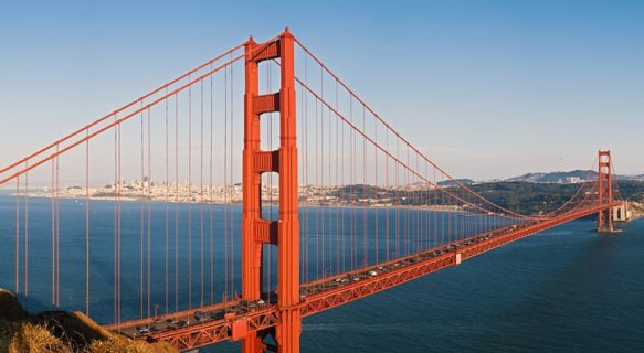
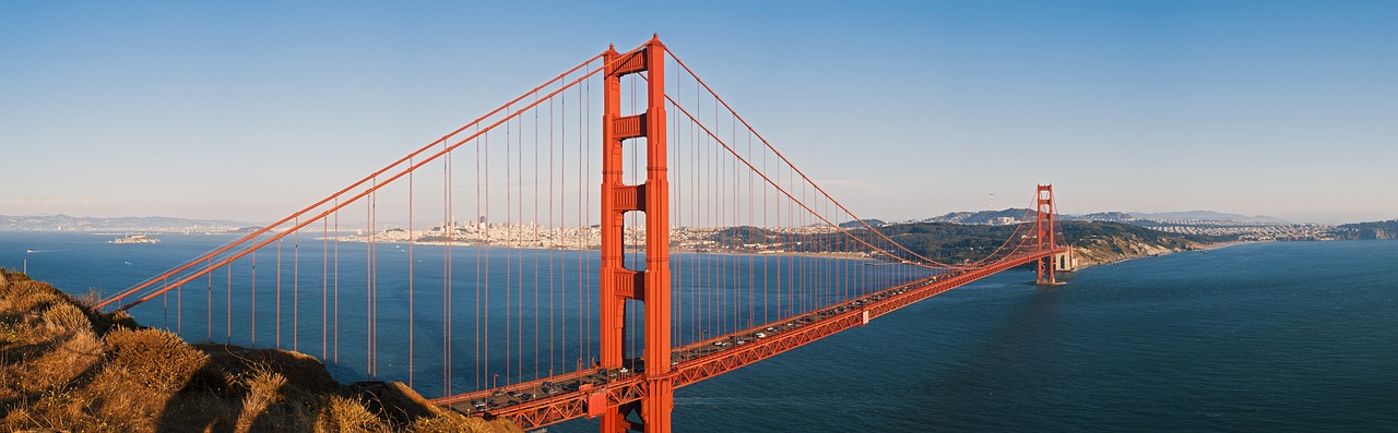
There are four major highway approaches to San Francisco. US 101 comes up the eastern side of the SF peninsula and is the most direct route from the south, although it often backs up with traffic. Interstate 280 is a more scenic route into the city from the same direction, but with poorer connections than 101. Interstate 80 approaches the city from the east over the San Francisco Bay Bridge. From the north, US 101 takes you over the Golden Gate Bridge.
Get around
- See also: Bay Area public transit

Cross streets. San Francisco streets are numbered (100 per block) from the beginning of the street, and even and odd numbers are always on opposite sides. In the absence of GPS navigation, it is best when getting an address to also ask for a cross street or neighborhood name. Most of the time, if a street touches Market Street (San Francisco’s main street), that’s the zero block. Addresses change by 100 each block, so a building at 1275 Foo street is often 12 to 13 blocks away from where Foo St. hits Market St.
Numbered streets and avenues. San Francisco has both numbered streets, in the Mission, the Castro, and SoMa, and numbered avenues in the largely residential Sunset and Richmond districts. Mixing numbered streets and avenues when asking directions may leave you miles from your destination. This can be confusing, as San Franciscans will not say “Street” or “Avenue” unless it is required to avoid ambiguity. Thus, they won’t say “I live on Fifth Avenue,” but will say “I live near Fifth and Geary.” Street signs generally don’t have “Street” or “Avenue” either; they just say “GEARY” or “MASONIC”, although numbered streets and avenues do.
Multiple street grids. One of the most confusing aspects of driving in San Francisco is the presence of multiple street grids, particularly in the downtown area where two grids intersect at an angle along Market Street. Even more confusing are streets in the middle of the standard blocks, like New Montgomery Street.
No left turns. Several key San Francisco arterial streets, including 19th Avenue and Market Street, do not have space for dedicated left turn lanes and therefore bear NO LEFT TURN signs at most intersections. As a result, you will be frustrated when you drive for miles on these streets with no opportunity to turn left. The trick, of course, is to go around the block with multiple right turns after passing one’s desired street, which requires you to stay in the right lane, not the left lane.
On foot
Walking can be an enticing option to get from one neighborhood to another, so long as you are aware of where you are and keep your street smarts. San Francisco is a city of friendly neighborhoods, but it is also a big city so be aware of your surroundings and keep in mind the dangers that commonly accompany a city of San Francisco’s size.
However, streets that often go straight up and down hills may make walking challenging when attempting the uphill portions (but provide good exercise). Driving can be difficult up and down hills but have breathtaking views. There are many stairway walks scattered throughout the city when the streets are too steep. You can find maps that include hiking trails, bikeways, and the grade pitch of all streets marked in varying colors by how steep each segment is, that can help you orient to city walks suitable to your ability and temperament, such as the downloadable map issued by the San Francisco Bicycle Coalition.
Note that locals rarely use the designations “street” or “avenue,” even when differentiating the numbered streets and avenues. Numbered roads designated “Street” are located on the east side of the city, south of Market in Downtown, Castro, Noe Valley, and Mission. Numbered roads designated “Avenue” put you in the Richmond and Sunset districts on the west side.
By public transit

San Francisco has one of the most comprehensive public transportation systems in the United States—arguably the most comprehensive system west of Chicago—and is expanding its network with a regional transportation hub in SoMa and a new subway line going under downtown. Transport services within San Francisco are provided by several agencies, but transferring between them is easy now with a Clipper Card. Clipper is accepted on essentially every transit system you’ll encounter:
- Muni — Metro, streetcars, buses, and cable cars within San Francisco proper. This is the main public transit system you’ll use for getting around in San Francisco.
- BART — Regional train services in the San Francisco Bay Area. You’ll mainly use this to get in and out of San Francisco, but you may use it, for example, to get between Downtown and the Mission. It overlaps with Muni along Market Street in Downtown. When you enter one of the stations on Market Street, be sure you get on the right system—either Muni or BART—for where you’re trying to go. If not, you’ll need to exit and beg the toll operators in the booths to refund your fare.
- Caltrain — Commuter rail services to San Jose and cities in between, like Palo Alto (where Stanford University is located).
- Ferry services — Golden Gate Ferries to the North Bay and San Francisco Bay Ferry to the East Bay (Blue & Gold Fleet ferries do not accept Clipper Card).
- Many other regional bus systems in the Bay Area — AC Transit (Oakland), Golden Gate Transit and Marin Transit (Marin County), samTrans (Peninsula), and VTA (San Jose), among others.
Information on all the Bay Area’s transit agencies can be found by dialing 511 while in the Bay Area or by visiting the 511 website, which has a useful trip planner.
Public transit payment

- The Clipper Card was fully introduced in 2010 and is a contact-less, multi-agency fare card similar to Octopus in Hong Kong, EZ-Link in Singapore and Charlie Card in Boston. Clipper Cards can be purchased online, at any MUNI ticket machine as well as at select retail locations around the city, especially Walgreens.
- As of September 1, 2012 new cards now incur a one time $3 fee (except when purchased in online in conjunction and linked with a credit card for autoload). The cards themselves have no expiration date and can always be reloaded with cash or passes, so be sure to hang on to yours for future visits. Clipper can either be set up with pay as you go with all transfers calculated automatically, a passport (daily and weekly passes) or a monthly pass. If you want to avoid the Clipper fee, most fares on Bay Area transit agencies except monthly passes are available in paper form, for which a Clipper is required.
- MUNI has also created a single-use “Clipper Ticket” as the new subway turnstiles no longer accept cash. You can still pay with exact change when boarding a streetcar above ground or a bus.
- If you plan on using the Cable Cars during your visit, a MUNI passport is a great value. A one-day passport (either as a scratch card sold at retail locations or loaded onto a Clipper Card) costs $20 and includes Cable Cars (normally $7 a ride) as well as all other MUNI rail and bus services. Three and seven-day passports are also available at $31 and $40, respectively. Keep in mind that passports are not valid on BART, ferries, Caltrain, or any regional municipal bus outside San Francisco — you’ll need to load cash onto your Clipper Card if you plan on using any of these services. A “day” is a calendar day, not a 24-hour period.
- Without a passport, the basic Muni fare is $2.25 for adults and $1 for children ages 5-17, seniors 65 and older and the disabled.
- MUNI operates on a proof of payment basis, sometimes called an “honor system with teeth.” Each fare paid is valid for 90 minutes of travel on the MUNI system (light rail, streetcar, or bus but not Cable Cars) including transfers and even return trips, as long as all travel is completed within the 90 minute limit. If you’re using a Clipper Card, be sure you “tag on” at any of the readers located near the streetcar or bus door to pay your fare and start the 90 minute clock. People using Clipper, a transfer or a passport can board at any door. Otherwise, board at the front door, pay cash, and keep the paper transfer ticket that the driver gives you as proof of payment. A benefit of cash is that the manually adjusted transfers will often give you more than 90 minutes of riding. MUNI fare inspectors and sometimes the police randomly patrol streetcars, subway stations and buses with handheld Clipper Card readers checking for proper fare. Residents who ride MUNI regularly report being checked once or twice a week on some lines, infrequently or never on others. The fine for being caught without proof of payment is $200, although tourists may be issued a warning if it’s their first offense. The onus is on you to keep track of the time. If you are using a Clipper card and are unsure if your time has run out, just tag the card onto the reader to check. If you have time left, you will not charged again.
- Cable Cars are not included in these transfers and cost $7 per ride (one way, no transfers), or $20 per day. Before 7AM and after 9PM, seniors and disabled pay $3 for cable car rides. Muni Passports and FastPasses greatly reduce this cost, including cable cars in the regular daily, weekly or monthly fares.
Planning your public transit trip
- Since there are multiple overlapping transit systems, the best way to plan your trip is to use an online service which integrates information from the various transit agencies (e.g., 511 or a third party service like Google/Yahoo/Apple maps).
- Muni arrival times for many lines are available at the bus/train stop (look for an overhead LED display at bus stops) or online at NextMuni. The sites listed above integrate information from NextMuni. An unofficial site is RescueMuni.com, which often has information on routes that are not listed officially.
- A portable wallet-sized map of San Francisco and all its public transit (MUNI, BART, Caltrain) is also available at stores around the city, at the Powell & Market cable car ticket booth, or through their website online. Many of the city’s bus stops also have posted copies of this map with the location of the stop marked, a godsend for lost pedestrians.
Muni
Again, this is the main system you’ll use when you’re in the city. Muni consists of several types of trains and buses:

- Muni Metro (Lines J, K, L, M, N, and T) is a modern light rail and subway system. It connects many southern and western neighborhoods to downtown, with connections to BART and Caltrain. Outside of the Market Street/Twin Peaks subway tunnel, Muni Metro operates as a surface light rail system, running in the center of the street with stops every couple of blocks. (Many of these stops are not wheelchair accessible – check the map to see which ones are.) Tickets can be purchased from ticket vending machines before boarding; if the stop does not have such a machine and you do not have a ticket, you must board through the front door and buy one from the driver or risk being fined by a fare inspector. MUNI Metro operates seven days a week from 4:30AM to 1:30AM. Between 1:30AM and 5AM, OWL Buses substitute for Metro service.
- The Historic Streetcar F Line uses historic streetcars, in original colors from several cities in the US and Milan, Italy. The line runs from Fisherman’s Wharf south along the waterfront Embarcadero to the ferry building at the foot of Market Street, then up Market Street on the surface to the Castro district. Board through the front door and buy tickets from the operator if you do not already have a transfer or pass.

- The world-famous Cable Cars run on three lines in the steep streets between Market Street and Fisherman’s Wharf: the north-south Powell-Mason and Powell-Hyde lines and the east-west California Street line. These cars are a fun ride, especially if you get to stand on the running board, if a bit impractical for everyday use (though residents of Nob and Russian Hills do, in fact, use them on a regular basis). The cable car is such an attraction that, especially on weekends, it takes longer to wait in line to ride up Powell Street than it does to walk the short but sloping distance. If you want to save yourself time standing in line at the turnaround, just walk up a couple of blocks to the next stop — the conductors save a few spaces for people boarding along the way; you won’t get first choice of seats, but you’ll save yourself a long time standing in line. Board through any door or just grab a pole on the running boards; tickets are checked and sold by a uniformed conductor. Do not buy tickets from anyone off the car except for clearly marked ticket booths — scam artists are common. If buying a ticket on board, try to bring exact change, as conductors do not always have it.
- Both diesel and electric trolley buses serve the rest of city. You can board through any door if you have a Clipper Card (just touch the card to the card reader) or proof of payment (a MUNI passport or a transfer). If you don’t, board through the front door and buy tickets from the driver. Buses are scheduled every 2 minutes on a few lines in rush hour, 8 to 12 minutes on most lines during the day, and 15 to 20 minutes at night or between outlying neighborhoods. From your phone, use NextMuni or dial 511 to learn when the next 3 actual buses are likely to reach a particular stop. Breakdowns or “bunching”, leading to waits of 30 minutes or more, are possible. Sometimes a parallel bus line just a few blocks’ walk away will be arriving sooner. Main service runs between 6am and midnight, with 30 minute all-night “Owl” service on key lines. MUNI also operates a few “Rapid” bus routes along some busy corridors that lack rail lines (Fulton, Geary, and Mission, for instance) which are designated with a “R” after the route number. These only stop at major intersections rather than every couple of blocks. Tourists who aren’t sure exactly where they’re going should consider avoiding the Rapids, so they don’t end up 10 blocks beyond where they want to be.
Other public transit options
These are mainly used for getting in and out of the city:

- BART, the regional metro, has eight stations in San Francisco, making it a nice way to get between well-trafficked parts of the city, especially downtown and the Mission. BART gets you across the Bay to Berkeley and Oakland and to the airports of San Francisco and Oakland. BART Trains run over 107 miles (172 km) of track, serving 46 stations. BART trains operate on third rail power and accelerate to speeds approaching 70 MPH (110 km/h). BART operates from 4AM to midnight M-F, 6AM to midnight Sat, and 8AM to midnight Sun. On weekdays, BART trains depart downtown San Francisco stations at three to four minute intervals. Outer stations in far outlying suburbs have a maximum wait of fifteen to twenty minutes between trains. After 12:30AM, AC Transit and other east bay transit providers provide late-night bus service, serving principal BART stations until about 6AM. BART routes are named for the two terminus stations, not by line color as denoted on the system map. For more information on BART, see the ‘Get in’ section above.
- Caltrain has three stops within San Francisco. Other than the 4th and King terminal in SoMa, these are the 22nd St. Station and the Bayshore Station (off Tunnel Ave), neither of which are particularly attractive for visitors. Of interest to visitors who wish to travel outside of the city is the Palo Alto Station (at University Avenue), across the street from the campus of Stanford University, and San Jose Diridon Station. Caltrain operates fast frequent commuter rail service, seven days a week. Service generally runs from 5AM to Midnight. For more information on Caltrain, see the ‘Get in’ section above.
By bike
If you have strong legs and can tolerate traffic with intermittent bike lanes, bicycles can be a convenient form of transportation in San Francisco. Although it’s dense, San Francisco is fairly small in land area—just 7×7 miles from north to south and east to west—so it’s fairly quick to get from one end to the other. But much of the terrain is hilly and hard to pedal up. Do not be misled by maps depicting the city’s strict, regular street grid, as even the straightest of San Francisco’s streets might include steep hills or even staircases instead of a roadway. San Franciscans who bike frequently find ways to “wiggle” — taking winding routes to avoid hills — around the steepest hills in the city. You might try using this flat route finder. You can also put your bike on the front of the MUNI buses if you get desperate. Also beware that some maps compress the horizontal scale of the western half of the city.
A classic and relatively easy ride is from the tip of Golden Gate Park’s panhandle in the Haight, along paths and JFK Drive through the park to Ocean Beach. JFK Drive is lightly trafficked, and closed to cars on Sundays.
Downtown, SoMa, and the Sunset, and Richmond districts are relatively flat. There are a number of bike paths and bike routes on city streets; the San Francisco Bike Coalition keeps a lot of information about them. There are a number of bike rental companies in town, including Dylan’s Bike Rental, Bay City Bike, Bike and Roll and Blazing Saddles Bike Rentals with locations in Fisherman’s Wharf, and the Bike Hut and Pacific Bicycle in SoMa. San Francisco Bicycle Rentals, with shops at Haight, Fisherman’s Wharf and Ferry Building, charges $5 extra to drop off a bike at a different shop.
The Golden Gate Bridge has sectioned off pathways on each side for pedestrians and bicyclists. If you choose to ride a bicycle across the Golden Gate Bridge, be aware that walkers always stay on the east side of the bridge and bikes are often to ride on the west (ocean) side of the bridge. When the Bridge is closed to pedestrians during nighttime, you may continue to bicycle across by stopping to press the buzzer at the automatically closed gates to be buzzed in and out. It is a pet peeve of many locals to have to dodge bicycles while jogging or strolling.
- . A new bikesharing program that has stations located throughout the Downtown area, particularly the Financial District, around the Civic Center, and in SoMa, with a few in North Beach and along the Embarcadero. A pass entitles you to unlimited rides under 30 minutes. $9/24 hours; $22/3 days.
By taxi
For a large city, San Francisco taxis are surprisingly inefficient and expensive, starting at $3.10 just for getting in the door. You can get an idea of how much particular taxi trips cost in San Francisco using the SFMTA’s webpage.
Except for near downtown business hotels, tourist destinations, and nightlife areas, taxis can be hard to find and hail—and calling for a taxi can mean a 30-45 minute wait, if the driver shows up at all.
If you are heading to the airport, call ahead with a specific pickup time to one of the many taxi companies. Schedule your taxi ahead of time because if you are going beyond 15 miles, you will end up paying 50% extra.
In recent years, there has been considerable controversy in San Francisco about increasing the number of taxis, but the situation is getting better.
Before coming to San Francisco, download apps for some popular alternatives to hailing a taxi (e.g. Uber, Lyft, and the taxi hailing app).
By Uber or Lyft
Lyft and Uber are the two major players in San Francisco that provide a ride-hailing platform for taxi-like services. Uber is vastly larger, and Lyft is originally known for a whimsical, homespun feel. These two companies are very price-competitive, with prices often differing by only a few cents, although it’s sometimes useful to compare prices for some rides, like going to the airport, which may differ by several dollars.
Before your visit, download and install the Uber and Lyft applications to your smartphone, and set them up with your credit card information. When you need a ride anywhere in the city, launch either app and arrange a ride. There is always a very good number of ride-hailing drivers available at all times, so you typically can get a ride within 10 minutes or less.
You can share the ride with strangers (“Lyft Line” or “Uber Pool”) for a reduced price and longer ride times, or you can keep the ride private if you want to arrive to your destination as quickly as possible. Both apps have different options for the kind of ride you can hail.
Lyft and Uber are by far the quickest way to get around the city, though a typical ride roughly costs twice as much as public transit.
Note that Lyft and Uber drivers are not employed by either company, although there is a screening process. The drivers are everyday people who use the app to sell rides in their own vehicles, so treat them respectfully as you would a friend giving you a ride. If you have any concerns or complaints about your ride, contact Lyft or Uber and they will typically respond in a timely manner.
By car

Perpetually-clogged traffic, steep hills, a confusing system of one-way streets downtown, expensive parking, and a fleet of parking control officers who zealously enforce parking laws can make driving in San Francisco extremely frustrating. Visitors to the city should seriously consider alternatives to driving when possible. A car is only useful for visiting destinations outside of the city, and even then you may be better off using public transit (especially crossing the Golden Gate Bridge into Marin County), a taxi, or another car sharing service.
Car rental is expensive, registration fees are the highest in any U.S. state, and because collisions are common, rates for liability insurance (legally required) are high as well. In addition, traffic from the Golden Gate Bridge uses surface streets either along CA-1, 19th Avenue or US-101 on Lombard and Van Ness.
The most difficult problem with a car in San Francisco is parking. It is scarce throughout the city. Garages, where they are available, are expensive ($20–30/day downtown). The city has recently enacted a variable-pricing scheme which makes parking on the most popular streets parking even more expensive. San Francisco has some of the strictest parking laws and enforcement in the country.
For day trips into the city, consider a park-and-ride at a Peninsula Caltrain station, at a Peninsula BART station, or at an East Bay BART station.
When parking on a hill (there are many in San Francisco), always apply the parking brake and turn your wheels (“curb your wheels”) so that the car will roll into the sidewalk instead of the street if the brakes give out. For example, when the car is facing uphill, turn the wheels toward the street; when facing downhill, turn the wheels toward the curb. Failure to park properly risks having your car roll downhill, and it is against the law; you will be ticketed for failing to curb your wheels.
When parking on any street, pay extremely close attention to all street signs, e.g., no parking during rush hour times (typically 7-9 am and 4-7 pm), street cleaning every two weeks or every morning, loading-only zones, etc. The SFMTA enforces these street signs very religiously. You will get a parking ticket (or worst, your car will get towed and ticketed) for even the smallest infractions. Also pay attention to any red curbs, which indicate no parking.
If your vehicle gets towed, you must pay an exorbitant amount of money at the city pound to retrieve it ($300+), plus the fine on the parking ticket. The typical parking ticket usually costs at least $70.
Vehicle break-ins are common occurrences in San Francisco. At best, a car window could get smashed and some valuables stolen, and at worst, the car could get stolen (although this is more of a problem for older cars). When leaving your car on the street overnight, take everything with you; never leave anything visible in the car.
Motorcycles and scooters are common in San Francisco, for good reason. The city is one of the most motorcycle-friendly places in the U.S. Street parking for motorcycles is plentiful and very cheap ($0.30 to $0.80 an hour). There are several motorcycle rental shops, along with many dealers, service shops, and motorcyclist hangouts.
As elsewhere in California, motorcyclists and passengers are required to wear helmets. When parking on the street, it is legal to park in between cars, as long as the parking meter is paid for. Parking on sidewalks is illegal.
“Lane splitting” (riding in between two lanes) is legal in California, but there are specific rules. Look up these rules on the California Department of Motor Vehicles website.
Motorcycle theft is a problem; always use a disk lock or secure your bike to a stationary object using a cable or chain.
Segways are somewhat popular among tourists. If you want to blend in, avoid them. So far there is only one authorized Segway dealer that rents out Segways, though various tour operators (many of whom operate from Fisherman’s Wharf) offer guided trips throughout the city.
See
San Francisco has much to see — these are just the most significant sights. For more detail see the individual district sections, often linked from this entry.
Two passes are available which offer discounts to many interesting attractions:
- San Francisco CityPASS. A relatively cheap and easy way to cover many attractions of the city is the CityPASS. For a cost of $94 for adults and $69 for children 5-11, you get admission to the California Academy of Sciences, a Blue and Gold Fleet bay cruise, the Aquarium of the Bay, and a choice between the Exploratorium or same-day admission to both the de Young Museum and the Legion of Honor. A CityPASS works for nine consecutive days starting with the use of your first ticket (each ticket only accounts for one visit to each attraction). The pass also includes seven consecutive days of MUNI and cable car fares.
- Go San Francisco Card. Another easy way to cover many attractions and tours is the Go San Francisco Card. This card covers admission to numerous attractions and activities, including sightseeing tours, bay cruises, an Alcatraz tour, and numerous museums. Various pass options are available, such as an all-inclusive pass that covers admission to all participating attractions but is only available in 1, 2, 3, 5 or 7-day periods, to “Explorer” and “Family Fun” passes that cover admission to only 4 or 5 attractions but are good for a full 30 days. Cost of passes vary; see website.
Itineraries
There are many highlight walks you can take to really capture the feel of the city and see a whole lot of attractions at the same time. Some of the best ones are:

- The Marina and the Presidio. Starting at Fort Mason on the eastern end of the Marina District, a stroll along the marina and the adjacent green will offer you excellent views of the Bay and the Golden Gate Bridge. At the other end of the Marina District, you can cross Marina Boulevard into the neighborhood to see the spectacular Palace of the Fine Arts and continue further inland into the heart of the Presidio, or you can proceed along the shoreline through Crissy Field to the Golden Gate Bridge.
- Cow Hollow. Union Street between Gough and Fillmore is one of the city’s finest shopping streets outside of the city center.
- Pacific Heights. Fillmore Street between Pine and Broadway is lined with a good mix of shopping, views, steep slopes, and some of the city’s largest and most expensive homes. Continue west along Broadway to Lyon Street and you’ll be at the top of the Lyon Street Steps, a long staircase with superb views over the Bay and the Palace of the Fine Arts that’s popular with local joggers.
- Russian Hill. Cozy and welcoming Russian Hill offers plenty of tucked-away stairways and hidden treasures for those who wander away from the cable cars rumbling along Hyde Street or the well-trafficked crooked section of Lombard Street. Stroll down the steps of Vallejo or Francisco Street, wander through the shady alleys past charming gardens and Victorian houses, and test your stamina on some of the city’s steepest streets.
- Nob Hill. California Street between Mason and Leavenworth sits atop lavish Nob Hill, where cable cars ply the center of the street past the grand hotels and luxury apartment buildings surrounding the Gothic-style Grace Cathedral.
- Telegraph Hill. Numerous tucked-away staircases, most notably the Greenwich and Filbert Steps on the east side of Telegraph Hill, offer a strenuous and unforgettably beautiful walk up to Coit Tower, past cottages, tranquil gardens, and wonderful views of the Bay, the skyline, and the surrounding hills. You might even be lucky enough to encounter Telegraph Hill’s resident flock of wild parrots on the way.
- North Beach. Busy Columbus Avenue cuts diagonally across the street grid from Fisherman’s Wharf to the landmark Transamerica Pyramid skyscraper in the Financial District, passing through the heart of North Beach with its grand churches and famous cafés once populated with Beat poets.
- Chinatown. Grant Street between Bush and Broadway takes you through the bustling heart of the famous district. Returning by the parallel Stockton or Powell will give you a better feeling of the day-to-day life of the residents, and are both good for those looking for imported commodities such as tea or herbs.
- Fillmore. Post Street from Laguna to Fillmore takes you past the upscale shopping and restaurants of Japantown. Turning left onto Fillmore Street, continuing across Geary and ending at Turk, takes you past internationally known jazz venues and a mix of Black and Korean-owned shops.
- Haight Ashbury. Haight Street from Divisadero to Stanyan covers the shopping district made famous in the 1960s for its hippie culture; at Stanyan the street becomes a path through Golden Gate Park to a popular site (then and now) for relaxing and concerts. For a quieter walk, stroll south on Ashbury from Haight, past Victorians that were once the home to 60s celebrities, then turn left on Frederick for a steep climb through Buena Vista Park, past stately oaks and splendid views of the skyline.
- Ocean Beach. Ocean Beach is entirely open to pedestrians in both the Richmond and Sunset districts from the Cliff House restaurant in the north to the zoo in the south. For a shorter walk, the windmills near Lincoln at the end of Golden Gate Park offer a good base for a stroll north.
- Lands End. Starting from the Cliff House at the north end of Ocean Beach, you can take a spectacular walk along the coastline with views over steep cliffs, crashing waves, shipwrecks, as well as the ocean and the Golden Gate. At the other end of the trail is the upscale neighborhood of Sea Cliff, home to the scenic China Beach tucked into a sea cove. Along the way you can take short detours to the intriguing ruins of Sutro Baths or venture uphill to the Legion of Honor museum with its excellent European art collection.
- Castro and Noe Valley. Market Street from Church to Castro followed by a left down Castro to 19th takes you through the center of the city’s gay district. Continuing up Castro Street over the hill from there takes you to 24th, the main drag of bohemian Noe Valley.
- Mission. Mission Street between 15th and Cesar Chavez streets provides a look at a neighborhood famous for its Latino food and culture. Parallel to Mission and just a block to the west, Valencia Street is lined with many higher end boutiques and offbeat cafés starting to characterize the neighborhood, and has little of the grit of Mission Street. 16th Street between Mission and Guerrero offers a diversity of cuisine and several hip bars.
Landmarks

Perhaps the most recognizable landmark in San Francisco and one of the most famous bridges in the world, the Golden Gate Bridge, spanning the Golden Gate, has been called one of the Seven Wonders of the Modern World and is the first thing you see of San Francisco if driving in from the north, as it is one of the major road routes into and out of the city. Overlooking the Golden Gate is the Presidio, a former military post with beautiful architecture and a very scenic park setting. Just outside the Presidio is the gorgeous Palace of Fine Arts, built for the 1915 Panama-Pacific Exposition and reminiscent of Roman and Greek architecture.
Within the center of the city, the famous cable cars run up and down the hills of San Francisco between Market Street and Fisherman’s Wharf and offer quite a ride (see above under Get around for more info). Atop one of those hills, Telegraph Hill in North Beach, is Coit Tower, a gleaming white tower dedicated to the San Francisco firefighters. At 275′ high, the hill is a healthy hike from the nearby neighborhoods just below. Another prominent tower nearby is the Transamerica Pyramid, the tallest and most recognizable building in the San Francisco skyline, located among the skyscrapers and highrises of the Financial District. Perhaps the most famous view of that skyline is from Alamo Square Park in the Western Addition district, home to the famous Painted Ladies row of Victorian houses, with many other pretty Victorians encircling the lovely park.
Over on Russian Hill is the famous stretch of Lombard Street between Hyde & Leavenworth, the (nearly) crookedest street in America. The city also has a twistier but less scenic stretch of street, Vermont Street on Potrero Hill. Other street oddities in San Francisco include 22nd Street between Vicksburg and Church in Noe Valley and Filbert Street between Leavenworth and Hyde on Russian Hill — At a 31.5% grade, these streets share the honor of the steepest streets in San Francisco.
Neighborhoods

San Francisco is also well known for its collection of unique and intriguing neighborhoods. Most tourists start with Fisherman’s Wharf; although many of the locals consider it a tourist trap, it is a great place to see amazing street entertainers, watch sea lions, visit museums, or take a cruise to the infamous Alcatraz Prison or the pleasant Angel Island. Working fishing boats still come into the small harbor here, and the district is home to several excellent seafood restaurants. The fresh breeze from the bay can provide a bracing setting.
Chinatown, centered around Grant Street from Bush to Columbus, is part tourist trap, part an exhibit of local life. Good eating places abound, and the side streets especially have stores one wouldn’t find in a mall. Stockton Street is where most locals do their shopping for groceries; be sure to sample some of the dim sum and other specialties offered in the many bustling shops. However, many local Chinese prefer to eat and shop in the new Chinatowns located in other neighborhoods such as on Clement Street between 2nd and 12th Avenues in the Inner Richmond neighborhood. The Muni #1 (California) and #2 (Clement, does not run at night) buses get people from one Chinatown to the other.
Closer to Downtown is the Civic Center, with its impressive Beaux Arts buildings including City Hall and the War Memorial Veterans Building, the celebrated Asian Art Museum, music and theater venues (including large concert halls and a renowned Symphony and Opera), and the main public library. Nearby, within the highrises of Downtown, Union Square is the heart of the city’s main shopping and hotel district, while SoMa to the south is rapidly gentrifying, home to the city’s main convention center and several new museums.
To the west of Downtown is Haight Ashbury, famous for being a center of the Hippie movement in the 60s and 70s. While tourism has softened the image of the neighborhood somewhat, the area still retains its distinct feel with small organic coffee shops and store after store selling marijuana-themed goods, tie dye tee shirts and hand bands. Nearby at the top of Market Street is the Castro, the center of San Francisco’s LGBT community, with numerous theaters and small shops and restaurants. Next door is the Mission District, home to the Mission Dolores Church, one of the oldest structures in the city, and a fantastic collection of murals of all sorts on the walls of many nearby buildings, especially on alleys between Market and Valencia.
Treasure Island, an artificial island half-way between San Francisco and Oakland connected to the Bay Bridge, has excellent views of the San Francisco and Oakland skylines and quirky structures from the international fairground-turned-navy base-turned-neighborhood. Accessible by Muni bus #25 from the Transbay Terminal in SoMa.
Museums

When the morning is foggy, you may want to spend a few hours in one of the city’s many world-class museums. Many museums offer free admission on certain days during the first week of every month. Golden Gate Park is home to the copper-clad M.H. de Young Memorial Museum, which houses an impressive collection of contemporary and indigenous art. The de Young Museum’s former Asian collection is now permanently housed in the Asian Art Museum of San Francisco, located in the Civic Center. Across from the de Young Museum stands the California Academy of Sciences, which holds a huge array of science exhibits, including an aquarium and a natural history museum. Lincoln Park, across the Richmond district from Golden Gate Park, is the home of the California Palace of the Legion of Honor, which houses an incredible collection of European art and makes for a good companion visit to de Young Museum, given that admission to either includes same-day admission to the other.
In Nob Hill, the Cable Car Museum offers exhibits on the famous moving landmarks of San Francisco and the opportunity to view the machinery that powers the cable cars. Another fun transportation museum is the small but charming San Francisco Railway Museum, on the streetcar line in the Financial District. Nearby SoMa is home to a growing number of museums, most notably the extensive and renowned San Francisco Museum of Modern Art, but also smaller specialized museums like the Yerba Buena Center for the Arts, the Children’s Creativity Museum, the Cartoon Art Museum, the Museum of the African Diaspora, the California Historical Society Museum, and the Contemporary Jewish Museum. Down near the Castro is a recent addition to the city’s museum scene, the GLBT History Museum, while a hill overlooking the Castro holds the Randall Museum, a lovely little children’s museum off the beaten path.
At the Hyde Street Pier in Fisherman’s Wharf you can board several historical ships, including the 1886 Balclutha clipper ship, a walking-beam ferry, a steam tug, and a coastal schooner. At Pier 45 just to the east, the World War II submarine USS Pampanito and the World War II Liberty Ship SS Jeremiah O’Brien can be visited. Nearby is the Aquarium of the Bay on Pier 39 and the Wax Museum. Just down the Embarcadero from the Wharf is the Exploratorium at Pier 15, which will keep your kids busy for an entire day with their science and perception exhibits. And just outside the Wharf in the Marina district is Fort Mason, home to a few cultural museums.
Parks and outdoors

San Francisco has numerous parks, ranging from the tiny to the huge. The most famous of them is Golden Gate Park in The Avenues, a massive (roughly 1/2 mile-by-four mile) urban oasis with windmills, bison, museums, a carousel and much more hidden among its charms. The park contains the antique palatial greenhouse of the Conservatory of Flowers, the modern and ethnic art focused de Young Museum, the large Japanese Tea Garden, the new California Academy of Sciences building designed by Renzo Piano and the Strybing Arboretum, a collection of plants from across the temperate world. Defining the extreme northwestern corner of the city is Lands End in Richmond, which provides majestic views of the Marin Headlands, the Golden Gate Bridge from the ocean side, and the Pacific Ocean itself. At the extreme western end the well known Cliff House provides both semi-casual and a more formal eating and drinking place overlooking the intriguing ruins of Sutro Baths.
Near the physical center of the city is the Twin Peaks, one of San Francisco’s highest points (875′ above sea level); providing spectacular views in all directions. Tour buses can get backed up here during the day, but it’s a great place to really appreciate the city from above, especially at and after sunset. Temperatures up there can be quite a bit lower than in the rest of the city, so bring a jacket. Nearby in the Lake Merced area is the San Francisco Zoo, a large and well maintained zoo which is a great place to go if you are traveling with children or have a fondness for penguins, primates, lions or llamas.
While not particularly well known for its beaches, San Francisco has a couple of good ones along the Pacific Ocean — but the water is brisk, the winds can be rough, and due to strong rip currents swimming at any of them is not recommended. Ocean Beach along the Sunset district is the largest and most famous beach, with plenty of sand and people enjoying themselves. China Beach in Richmond and Baker Beach in Golden Gate are smaller, rather secluded beaches with lovely views.
Off the coast of San Francisco is one of the most productive marine environments on Earth, which attracts abundant marine life including blue whales, gray whales, humpback whales, dolphins, seals and sea lions, leatherback sea turtles, and many species of seabirds. The rocky Farallon Islands, located roughly 30 miles offshore from San Francisco, are part of a National Marine Sanctuary and provide nesting habitat for tens of thousands of seabirds. The islands are also known for attracting large numbers of great white sharks from September through November. It is possible to take boat tours to the Farallon Islands throughout most of the year and go whale watching, departing from Fisherman’s Wharf or the Marina in San Francisco.
On sunny days hipsters flock to Mission Dolores Park, so named due to its location across the street from the Mission Dolores Basilica. The park often comes to resemble a large party, with music, coolers of beer and, er, uh…medical marijuana treatment. Mission Dolores Park is situated on a slight slope on the edge of the Mission neighborhood, just a few blocks from the district’s many restaurants and bars. The east side of the park is bounded by Dolores Street, a hilly and scenic drive lined with palm trees and Victorians.
In the southern half of the city is the often overlooked but wonderful Bernal Heights Park, a small park on top of a hill overlooking the entire eastern half of the city, with excellent views of the skyscrapers in the Financial District, the Mission District, and the hills in the southeastern corner of the city. A wide trail runs around the base of the park below the peak which can be walked in ten to fifteen minutes. Bernal Heights Park is dog friendly, so much so that a coyote is often observed there.
Do
Harbor tours

One of the best ways to see San Francisco is from the waters of San Francisco Bay. There are many companies offering harbor tours of varying durations and prices but they all provide marvelous views of the bay, the bridges, the island of Alcatraz and the city.
Only specific island tours are allowed to land at Alcatraz, but the typical harbor tour will circle the island at a slow crawl, giving you plenty of opportunity to photograph the now-inactive prison from the water.
Also consider taking a ferry from San Francisco across the bay to Tiburon, Sausalito, or Alameda. Same views for a fraction of the price.
Most tours leave from docks at Fisherman’s Wharf near Pier 39. Tickets can be purchased at kiosks along the waterfront walk. Buy tickets a day or two in advance during the summer high season.
Boats usually leave roughly hourly starting around 10AM and ending around 5PM. Multi-lingual guides are available on some tours. Prices range from $20–$40, more for sunset, dinner, or whale watching tours.
- Even on a sunny day the bay can be chilly, so be sure to bring a sweater as well as sun screen.
- Some boats have snack bars on board, but bring your own water and treats to avoid paying high costs or going without. There are now limited refreshments and a souvenirs shop on Alcatraz.
Performing arts

- San Francisco has a Half-Price Ticket Booth located right in the middle of Union Square, where tickets for most San Francisco theater performances can be purchased the day of the performance for half-price. Run by Theatre Bay Area, all service fees collected from the sale of tickets by TIX Bay Area goes right back into the theater community.
- Go to a concert, a play, a jazz or a folk-song performance. There are performances most days to choose from by the San Francisco Opera, the San Francisco Symphony, in Herbst Theater (where the U.N. charter was signed), in the Old First Church, and for musicals in the Orpheum or the Golden Gate Theaters, all located in or near the Civic Center. The museum of the Legion of Honor, located in Lincoln Park overlooking the Golden Gate (north end of 34th Ave), has organ concerts which can be heard in many of its galleries, Saturdays and Sundays at 4PM, as well as music performances in its Florence Gould Theater by the San Francisco Lyric Opera. For the fall and spring jazz festivals look into the SFJAZZ calendar. San Francisco also has many jazz clubs, best found by browsing the web (an excellent site is SFStation.com). Contemporary bands are featured at The Fillmore Auditorium and less frequently at the large Bill Graham Civic Auditorium in the Civic Center. There is an annual blues festival in late September, at various locations, and at least two great bluegrass music festivals each year — during February around the area and late September or October in Golden Gate Park. Many, but certainly not all, events are listed by the City Box Office.
- Ballet of the world class variety can be seen for only $10. San Francisco Ballet sells standing room tickets (with excellent views from the back of the orchestra) for their shows at the War Memorial Opera House in Civic Center during the afternoon of each performance as well as two hours before showtime.
- Plays are performed at the Geary (by the American Conservatory Theater), Curran, and the Marines Memorial theatres near Union Square, and at the small New Conservatory Theater near the Civic Center.
- Musicals from Broadway and Los Angeles are shown at the traditional Golden Gate and Orpheum theaters on Market, near the Civic Center. For outrageous fun, princes and paupers go to Beach Blanket Babylon in North Beach. Teenagers are welcome at the Sunday matinees. It considers itself the longest running musical revue in theater history.
Events
There is an incredible array of events going on in San Francisco — virtually every day there will be something of interest to anyone going on, and San Francisco’s mild climate ensures that practically every weekend will bring another major festival or some sort of large event. Listed here are just some of the really big events going on:
Cultural events
- Tet Festival: . Civic Center-Tenderloin area. Mid-January to mid-February. Celebrate New Year’s Vietnamese style at this festival. It’s a great opportunity to sample some of the delicious Vietnamese dishes that they have in the area. (date needs fixing)
- Cherry Blossom Festival: 11–19 April 2015 . Western Addition. April. In Japantown, this kid-friendly event includes a parade, a street fair, and music. (date needs updating)
- San Francisco International Film Festival: 23 April – 7 May 2015 . Based at the Presidio in Golden Gate, but smaller events take place throughout the city. Two weeks in Apr/May. Organized by the San Francisco Film Society who are based in the Presidio, but the arthouse movies, documentaries, and short films are shown throughout the city. (date needs updating)
- Union Street Art Festival: 4–5 June 2016 . Golden Gate. First weekend in June. This festival attracts many local artists who line the streets displaying their arts and crafts, along with live jazz and classical music performances and an organic farmer’s market. (date needs updating)
- Haight Ashbury Street Fair: 8 June 2014 . Haight. On the second Sunday of June, people pack the Upper Haight for this event featuring local bands, food stalls and plenty of shopping. (date needs updating)
- Fringe Festival: 11–26 September 2015 . Taking place at various theaters in the Civic Center-Tenderloin area. Just after Labor Day. A 10 day festival about theatrical experimentation and having fun, even if you don’t know what you’re doing exactly. (date needs updating)
- Folsom Street Fair: 25 September 2016 . Unsurprisingly, on Folsom in SoMa, last Sunday in September. Advertised as the world’s largest leather/fetish event. Not really one for the kids. (date needs updating)
Holidays
- Chinese New Year Festivities, Chinatown. January or February. The San Francisco version of the Chinese New Year dates way back, with a colorful, vibrant parade with decorative costumes, lions, deafening firecrackers, “lucky-money” envelopes, colorful banners, ornately themed floats, martial arts groups, stilt walkers, acrobats, and, of course, a 200 foot Golden Dragon.
- Easter Parade and Spring Celebration, Union Street in Golden Gate. The kid-friendly but diverse festivities include a petting zoo, pony rides, live music, train rides, alfresco dining, and a parade.
- Fourth of July. San Francisco’s main Independence Day celebrations take place on Fisherman’s Wharf. There is lots of free entertainment during the day, culminating with an impressive fireworks display from the foot of Municipal Pier, and at the other end of the Wharf from barges moored off the north of PIER 39.
- Columbus Day Parade, North Beach. This hugely popular parade celebrates Christopher Columbus and Italian heritage. Handmade floats run all the way from Fisherman’s Wharf up Columbus Avenue through North Beach.
- Tree Lighting Ceremony at Ghirardelli Square, Ghirardelli Square, Fishermans’ Wharf. End of November. Ring in the holiday season by attending the festivities at Ghirardelli Square. There’s theater, live music, and then at the end they decorate a 45 foot Christmas tree with ornaments, lights, and chocolate bars.
Outdoor and recreational events
- Critical Mass. On the last Friday of each month, bicyclists in San Francisco (and about 200 like-minded cities world-wide) gather at the north end of Market Street on the Embarcadero and ride en masse to some destination, demonstrating their right to use the roads. If you are driving in SF on a Critical Mass day, you will want to listen for radio traffic reports, but if you are stopped by the mass the best thing to do is maintain a good sense of humor and remember that it will all pass in about 5 minutes. Tempers can and do flare, and there have been cases where run ins with drivers and bicyclists have gotten violent. If your car is surrounded by bikes, definitely do not move until they have passed or they might feel threatened.
- Bay to Breakers. Third Sunday in May. An annual footrace that is one of the largest in the country. The route runs from Downtown to Ocean Beach. Many runners do the whole thing in costume, wearing anything from elaborate costumes to wearing almost nothing at all, lending a party atmosphere to the event.
- Escape from Alcatraz Triathlon. Second Sunday in June. Participants (which often include world champions and Olympic medalists) swim 1.5 miles through chilly waters, bike 18 miles, and then run an extra 8 miles. The course winds its way throughout the city, but the transition and finish line is at Marina Green in the Golden Gate area.
- Fleet Week, Fisherman’s Wharf. Usually held in the first week of October, it’s a tribute to the men and women in the armed forces. A flotilla of Navy ships dock on the Wharf in parade fashion, and there are many free Deck tours available from crew members. There are also several air displays by the Navy flyers.
- Sunday Streets. Is an approximately monthly event rotating through various neighborhoods where the local main street is closed to car traffic for a pedestrian street fair.
Sports

The Bay Area has several professional sports teams, although most of those teams play in nearby San Jose and Oakland rather than San Francisco itself. The National Football League‘s San Francisco 49ers moved from Candlestick Park (which has since been demolished) in San Francisco to Santa Clara in 2014.
The San Francisco Giants are the city’s Major League Baseball team, playing their home games at the lovely AT&T Park in SoMa and commanding a large and devoted fan base. With the Niners’ move to Santa Clara, the Giants are the only team in America’s major sports leagues playing in the city itself. As far as college sports go in San Francisco, the only NCAA Division I program in the city itself is the San Francisco Dons, representing the University of San Francisco and playing various college sports including baseball, basketball, soccer and volleyball at their campus in Western Addition. The San Francisco State Gators, an NCAA Division II program, play various college sports including baseball, basketball and soccer at their campus near Lake Merced.
Local music
San Francisco is a hotbed for underground music; a highly diverse array of musical styles is represented (e.g., rock, pop, experimental, weird folk, and avant-jazz). Shows occur every night, with as many as fifteen small shows occurring each Thursday through Saturday night. Much of this activity is not always well covered in the mainstream media; useful community-driven resources for finding about local shows include the Transbay Calendar.
Learn
There are three world-class research universities in the Bay Area: University of California, San Francisco with two large campuses in San Francisco focused on biomedical research and training; University of California, Berkeley in Berkeley; and Stanford University in Palo Alto. Many of the major businesses in the area have a connection to one of these universities.
The University of California, San Francisco is one of the city’s largest employers and is dedicated solely to the education of health and the biomedical sciences. Unlike many other universities, it does not have undergraduate programs and only admits graduate students. Also in the University of California system is the Hastings College of the Law, a major law school located in downtown San Francisco. The San Francisco State University is another major public university that offers a broader range of studies than the UC colleges in the city. Rounding off the city’s public colleges is the City College of San Francisco, a two-year community college.
San Francisco also has numerous private colleges and universities, some of them large, such as the University of San Francisco located in the Richmond district, and Academy of Art with properties throughout the city.
Work
While San Franciso’s economy is linked to it being a world-class tourist attraction, its economy is diversified. The largest employment sectors are professional services, government, finance, trade, and tourism. Its frequent portrayal in music, films, literature and popular culture has helped make the city and its landmarks known throughout the world. San Francisco has developed a large tourist infrastructure with numerous hotels, restaurants, and top-notch convention facilities.
While it’s been a long time since people considered Montgomery Street in the Financial District to be the “Wall Street of the West”, San Francisco remains the undisputed financial capital of the West Coast, home to the headquarters of some of the world’s major financial institutions such as Wells Fargo Bank as well as the regional headquarters of the United States Federal Reserve. Many major financial institutions and banks are based in the city or have set up regional headquarters here.
San Francisco’s proximity to Silicon Valley has made the city increasingly attractive for high-tech companies. While most of the large technology companies are in the valley, many tech workers live in San Francisco and commute to work. In recent years, San Francisco has also been making itself a center of biotechnology.
Buy
If you want it, chances are likely you can get it in San Francisco. There are a wide range of small and locally owned businesses throughout the city’s neighborhoods; in fact, San Francisco has for the most part repelled the development of large chain retailers and big box stores that are common across America.
If it’s tourist trinkets you’re looking for, Fisherman’s Wharf has the typical souvenir, T-shirt, and camera shops, along with plenty of specialty stores. However, San Francisco’s most popular shopping area is Union Square, which has all the big national department stores (Macy’s, Saks, Nordstrom, etc.) and plenty of fancy boutique stores, as well as a few shopping centers thrown in.
For small, upscale boutiques, Union Street, Fillmore Street, and Chestnut Street in the Golden Gate area are lined with unique and trendy places, and all three streets are among the best spots in the city to window shop. Nob Hill is also full of specialty places.
But if you don’t have a luxury dollar to spend and still want to walk away with something unique, there are plenty of shops in Chinatown for you, selling Oriental handicrafts of all descriptions, and no chain stores in sight. Japantown also offers plenty of great shops selling authentic souvenirs, including the excellent Kinokuniya Stationery/Bookstore. The Haight is full of excellent independent record and book stores, with Amoeba Music dominating the scene.
Eat

San Francisco is a “foodie” city with a vast array of restaurants. In fact, San Francisco has more restaurants per capita than any major city in North America, with 1 restaurant for every 250 residents (in comparison, New York City has 1 restaurant for every 940 residents). The price range is huge, of course, and you can spend anywhere from a small fortune to a couple bucks for every type of cuisine. In addition to the range of ethnic restaurants you’d expect to find, bay area food culture focuses on “artisinal” food (see the Ferry Building) and fresh fruits and vegetables (see Alice Waters), drawing from the nearby farms in California.
In San Francisco, you would be well-served by using an online restaurant rating website to find the best restaurants. Yelp.com, for example, is actively maintained by San Franciscans. All the best restaurants (and bars) are mobbed on the weekends, so you’ll do well to check out the availability on opentable.com or similar websites.
Ethnic food and neighborhoods:
- You can still find some ethnic food districts in San Francisco. Some of these, like North Beach, have become museums for tourists, while others, such as the (Inner) Mission and Chinatown, are still strongly ethnic neighborhoods which maintain their native food culture. In truth, the food culture in the city is oriented less around ethnic districts than restaurant areas. In the Mission, for example, you will find not just Mexican food but rather excellent options of many kinds (e.g., Sushi, Indian, Italian, Thai, etc.).
- With the largest Chinatown in North America as well as one of the largest Chinese communities in the West, there are many exceptional restaurants serving dim sum and other Chinese delicacies found throughout the city. This localized Chinese cuisine has its feet in Hong Kong and America, and is different from what many visitors are accustomed to — it is common to hear complaints from Chinese visitors that Chinese food here is not like the food back home. There are several main types of Chinese restaurants in San Francisco: those primarily serving immigrants from Hong Kong (“Hong Kong style”) which commonly have signs on the wall in Chinese characters, live fish and shellfish tanks and some exotic main ingredients, such as pig’s blood or sea cucumber; those primarily serving San Franciscans who are not Asian immigrants (“California Chinese”) which commonly have Westernized table service, low fat content and more emphasis on fresh vegetables; those primarily serving tourists or other people accustomed to Chinese food as it is commonly served in the United States (“Americanized Chinese”); and those primarily serving immigrants from other areas or a particular dietary need or interest (regional cuisines, vegetarian, Muslim). There may be some mixing between these various classifications and each category may influence the others, for instance, the Americanized dish known as Chop Suey is often not served even at Americanized Chinese restaurants in San Francisco, while Chinese vegetables such as bok choy and pea sprouts may turn up on your plate at California Cuisine style restaurants.
- San Francisco is also one of the best places in the nation for other Asian cuisine: Korean, Thai, Indian, and Japanese. Sushi is a local obsession. Japantown and the Richmond district have more than their fair share of excellent sushi chefs.
- Inexplicably to many locals, Fisherman’s Wharf remains a popular place for tourists to find fresh but overpriced seafood, especially clam chowder and crabs cooked to order.
- For tourists, North Beach is the place to go for Italian food. Beware that the restaurants along Colombus, which are oriented toward tourists, will be overpriced. You can, of course, find great Italian and pizza all over the city.
- The Mission (birthplace of the mission style burrito) is great for Mexican and Latin American cuisine of all sorts.
San Francisco restaurants are also very corkage friendly. Average corkage fee appears to be in the $15 range, with some of the more pricey places charging $25–35.
Vegetarians and vegans will find SF a paradise, however contrary to popular belief the city has one of the lowest rates of vegetarian consumers in the nation.
Drink
Bars and clubs
The best way to find a good bar or club is to ask the advice of a local; but barring that a copy of The SF Bay Guardian or the SF Weekly or a quick search on yelp/google will help you find something suited to your personal taste.
The great diversity of nightlife in San Francisco, sometimes within one neighborhood, reflects the diversity of cultures there. Here’s a sampling:
- If you want door-to-door bar hopping at friendly bars that serve PBR tall boys, definitely go to “Polk Gulch” in the Tenderloin and work your way north through bars such as Mayes and Hemlock.
- Head to the Marina for mid-20s to mid-30s professionals (and those visiting from Los Angeles) as well as a college atmosphere clubbing scene around super packed club/bars such as Circa.
- Are you into clubs? If you want to commit to a single venue for the night and club the night away, pay the necessary cover at high end clubs in South of Market (SoMa) such as The Grand and Manor West, where you can find left-over dot-commers and hipsters hanging out on the street. If you’re in the mood for world class clubbing, Ruby Skye near Union Square is a must visit place; the SF equivalent of a Vegas club, but be prepared to buy tickets ahead of time and wait in line.
- The Mission offers a more down to earth vibe that still lets you get your dance on; a bonus with this is that you can end the night with a great burrito from one of the local Mission taquerias.
- With a large Irish population, San Francisco has a number of very good Irish pubs (e.g., Danny Coyle’s in the Haight, Four Deuces in the Sunset, and many others). North Beach is home to several dance clubs and strip clubs.
- If you like soccer (football) and all things English, you should stop into the Kezar Pub, at the edge of the Haight-Ashbury District, or Lower Haight‘s Mad Dog In the Fog. The pub quiz and bar food are good. Swill some pints and stay in the dark. Good for an entire day’s worth of drinking.
Beer
San Francisco, despite being much smaller than New York City, sports more microbreweries. Anchor Brewing Company (makers of Anchor Steam, found throughout the US) is brewed on Potrero Hill, though it is generally not open to the public (tours are available by reservation). They maintain a beer garden at the Yard at Mission Rock, just across from the ballpark. Similarly, Speakeasy Ales & Lagers opens its doors on Friday evenings and Saturday afternoons, though its location in Hunter’s Point makes it a long Muni ride if you’re traveling without a car. The other microbreweries are housed in brewpubs:
- Beach Chalet & Park Chalet are at the Pacific end of Golden Gate Park, where you can enjoy a view of the ocean or sit in the lawn area.
- Pizza Orgasmica in the Richmond District specializes in California-style pizza.
- Magnolia Brewing Company is in the heart of the Haight, and operates a second restaurant down the street, The Alembic, as well as well as a barbeque joint with their beers in Dogpatch, Smokestack.
- Thirsty Bear in SoMa caters mostly to the happy hour crowd.
- 21st Amendment, also in SoMa, is three blocks away from the Giants’ home at AT&T Park.
- Social Kitchen & Brewery is in the Sunset District, a block from Golden Gate Park.
- Southern Pacific Brewing Company is a large bar in the Mission District.
- Cellarmaker Brewing Company is a highly regarded brewery in SoMa, with an emphasis on hop-driven beers.
Other destinations for beer drinkers include the City Beer Store and Tasting Bar on Folsom St in SoMa (your best bet for beer to go), the Mission’s Monk’s Kettle, and the famous Toronado Pub on lower Haight Street, which specializes in Belgian ales.
The surrounding Alameda, San Mateo, and Marin Counties also host many microbreweries worth trying. Many of these are accessible by BART. And although Santa Rosa is 45 minutes north of San Francisco, no beer lovers should skip the renowned Russian River Brewing Company in downtown Santa Rosa.
Sleep
San Francisco offers a wide range of accommodations, from a healthy supply of hostels and budget hotels to the lavish, luxurious hotels in the city center, as well as just about everything in-between. The majority of accommodations are in the northeastern portion of the city, in and around the popular areas of Downtown, Chinatown, and Fisherman’s Wharf. As one moves into the mostly residential neighborhoods to the west, the sleeping options filter down to small inns and bed and breakfasts.
Decide if you want to be in walking distance of your destinations, or are up to driving and parking (which can be quite an undertaking in some of the busier areas of San Francisco) or taking public transit. If you have a specific destination in mind, look also in the Districts sections.
If you’d rather stay closer to the San Francisco International Airport, there are plenty of standard airport accommodations in the cities surrounding the airport — Brisbane, Burlingame, Millbrae, San Bruno and South San Francisco. From there, you can drive or take BART or Caltrain into San Francisco.
Connect
The area codes for San Francisco are 415 and 628. You need to dial 1+area code+number for all calls within the city. For calls within the US or Canada, dial 1+area code+number, and for international calls, dial 011+country code+city code(if applicable)+number. Pay phones are getting less and less commonplace as nearly everyone in San Francisco has a mobile phone. When you do find one, keep in mind that they only take coins and phone cards with a dial-to-use number. Local calls start at $0.50.
To get online, internet cafes are available at a sprinkling of city center locations. Many coffee houses and cafes also offer wireless connection for free or a small fee. Free access is available in Union Square. For a more scenic place to check your email try the Apple Store on Stockton at Ellis near Market in Union Square or any of the many public libraries, especially the main branch on Market near Civic Center station.
Blue mailboxes for mail such as letters and postcards are on many street corners. USPS post offices sell stamps and ship packages, and several private companies provide additional services.
Stay safe
A look at Stanley Robert’s People Behaving Badly series will give you an inside look of usually petty crime in the city. However, it is very unlikely you’ll encounter any violent or petty crime as long as you use your common sense and are vigilant.
The areas that one should be most cautious are in the neighborhoods of Bayview-Hunters Point, Visitacion Valley, Sunnydale, Ingleside, and Potrero Hill in Southeast San Francisco, as well as the Tenderloin, parts of Western Addition (including the Fillmore District), and parts of the Mission. San Francisco is still susceptible to violent crime, and most of these murders occur in the southeast, less economically fortunate, neighborhoods of the city. Gang violence touches even busy and thriving areas such as the Mission Street retail corridor, although most instances of violent crime are directed to specific targets and are not random acts. The SoMa district used to be somewhat dangerous; however, recent gentrification (something that has become fairly common and a social issue in SF) has transformed it into a rather hip and much safer neighborhood with plenty of art galleries and clubs. However, it is best to be careful even now.
San Francisco also has the largest homeless population per capita in the United States. If someone begs from you, you may either politely say you do not have any change or just keep walking, and he or she will generally leave you alone. The main homeless area is around 6th and Market, heading towards the Civic Center, and in the Tenderloin. Haight Ashbury also has lots of panhandlers, and the area near Golden Gate Park at the end of Haight Street near McDonalds is notorious for junkies and should be avoided at night.
Pickpocketing, purse snatching, and other forms of petty crime are common as with any other large city. Be especially cautious on crowded Muni trains and buses, in heavily touristed areas such as Fisherman’s Wharf, and during the busy holiday shopping season.
Do not leave valuables in your vehicle, especially when parking on public streets. Car break-ins are very common in San Francisco, and any valuables in plain sight are in danger of being stolen. During your visit, you will probably see small piles of broken glass on sidewalks throughout the city, which are the result of such crimes. If you cannot carry all valuables with you, try to keep them in the trunk and park your vehicle in secure parking garages, which are slightly safer than street parking but are not completely free from crime either. Bicycle theft is extremely common so bikes should be securely locked to a sturdy surface, even if you’re going to only be gone a minute.
Be careful to check for ticks after hiking in fields in the Bay Area. There is a high rate of lyme disease transmission in the Bay Area. If a bulls’ eye rash develops at the tick bite site, immediately seek medical help and treatment with antibiotics.
Cope
Publications
- San Francisco Chronicle. The main newspaper in San Francisco, with circulation daily. $0.75 daily, $2.00 Sunday.
- San Francisco Examiner. Another daily newspaper, but this time free.
- SF Weekly. A popular free-weekly distributed across the city.
- San Francisco Bay Guardian. Another popular free-weekly.
- San Francisco Bay View. Politics, economics, and news from a progressive African American perspective.
- AsianWeek. A weekly paper, one of the largest English language publications for Asian-Americans.
- San Francisco Magazine. A monthly magazine devoted to Bay Area culture.
Consulates
San Francisco is home to many people of different nationalities and language backgrounds. Therefore, many countries have established full service consulates (Consulates Generals) in San Francisco to provide consular services for their nationals living in (northern) California and in the adjacent states in the northwestern part of the U.S. (or the entire west coast) as well as visa services for others seeking to visit their respective countries (if required). The Honorary Consulates are there for commercial and business purposes and offer limited or no consular services except in emergency situations. Most of the consulates are in downtown San Francisco and in the adjacent Pacific Heights & SoMa areas. They can also be located in other parts of town too:
 Australia, 575 Market St Ste 1800, ☎ +1-415-644-3620, fax: +1-415-536-1982.
 Belgium (Honorary), 1663 Mission St Ste 400, ☎ +1-415-861-9910, fax: +1-415-861-9801, e-mail: consubelsf@gmail.com.
 Brazil, 300 Montgomery St Ste 300, ☎ +1-415-981-8170, fax: +1-415-986-4625, e-mail: brazilsf@brazilsf.org.
 Cameroon, 147 Terra Vista Ave, ☎ +1-415-921-5372. By Appointment.
  Canada, 580 California St, 14F, ☎ +1-415-834-3180, fax: +1-415-834-3189, e-mail: sfran@international.gc.ca.
 Chile, 870 Market St Ste 1058, ☎ +1-415-982-7662, +1-415-982-7665, fax: +1-415-982-2384, e-mail: cgchile.sf@minrel.gov.cl. M-F 9AM-5PM.
 China, People’s Republic of, 1450 Laguna St (Hwy 101 to Fell St exit), ☎ +1-415-674-2940. M-F 9AM-noon, 1PM-3PM.
 El Salvador, 507 Polk St, Ste #280, ☎ +1 415-771-8524. Mon-Fri 07:30-14:00.
  France, 88 Kearny St,Ste 600, ☎ +1-415-616-4906, fax: +1-415-433-8357. Mon-Fri 09:00-12:00 for French nationals; Visa Section Mon & Wed 9:00-12:00 & 14:00-15:30 and Tue, Thu-Fri 09:00-12:30.
 Germany, 1960 Jackson St, ☎ +1-415-775-1061, fax: +1-415-775-0187. M-F 9AM-noon.
 Greece, 2441 Gough St, ☎ +1-415-775-2102, fax: +1-415-776-6815, e-mail: sfgr@greekembassy.org.
 Guatemala, 544 Golden Gate Ave, ☎ +1 415-563-8319. Mon-Fri 08:00-14:00.
  Honduras, 870 Market St, Ste 875, ☎ +1 415-392-0076. Mon-Fri 09:00-15:00.
  India, 540 Arguello Blvd, ☎ +1-415-668-0662, +1-415-668-0683, fax: +1-415-668-9764.
 Indonesia, 1111 Columbus Ave, ☎ +1-415-474-9571, fax: +1-415-441-4320, e-mail: sanfrancisco@indonesia-sanfrancisco.net.
 Ireland, 100 Pine St 33F, ☎ +1-415-392-4214, fax: +1-415-392-0885.
 Italy, 2590 Webster St, ☎ +1-415-292-9210, +1-415-931-4924, fax: +1-415-931-7205, e-mail: visti.sanfrancisco@esteri.it.
 Japan, 275 Battery St, Suite 2100, ☎ +1-415-780-6000, fax: +1-415-767-4200, e-mail: con-e@sr.mofa.go.jp.
 Korea, Republic of, 3500 Clay St, ☎ +1-415-921-2251, fax: +1-415-921-5946.
  Mexico, 532 Folsom St, ☎ +1-415-354-1732, fax: +1-415-495-3971.
 Netherlands, 1 Montgomery St Ste 3100, visiting address 120 Kearney St Ste 3100, toll-free: +1-877-DUTCHHELP (388244357), e-mail: sfn@minbuza.nl.
 New Zealand (Honorary), ☎ +1-415-399-1255, fax: +1-415-399-9775, e-mail: NewZealandHCSF@gmail.com.
 Norway, 20 California St, 6th Floor, ☎ +1-415-986-0766, fax: +1-415-986-3318, e-mail: cqsfo@mfa.no.
 Peru, 870 Market St, Ste 1075, ☎ +1 415-362-5185, +1 415-215-6668 (emergencias). Mon-Fri 09:00-14:00.
  Philippines, 447 Sutter St, ☎ +1-415-433-6666, fax: +1-415-421-2641.
 Portugal, 3298 Washington St, ☎ +1-415-346-3400, fax: +1-415-346-1440, e-mail: sfrancisco@mne.pt.
 Russian Federation, 2790 Green St, ☎ +1-415-928-6878, +1-415-928-6878, fax: +1-415-929-0306, e-mail: russianvisa@att.net. Closed till further notice. Due to tensions between U.S. and Russian relations they have closed the consulate in San Francisco. Next nearest Russian consulate in the west coast is in Seattle
 Spain, 1405 Sutter St, ☎ +1-415-922-2995, +1-415-922-2996, fax: +1-415-931-9706, e-mail: Cog.sanfrancisco@maec.es.
 Switzerland, 456 Montgomery St Ste 1500, ☎ +1-415-788-2272, fax: +1-415-788-1402, e-mail: sfr.vertretung@eda.admin.ch.
 Taiwan, Republic of China (Taipei Economic and Cultural Office), 555 Montgomery St, Suite 501, ☎ +1-415-362-7680, fax: +1-415-364-5629, e-mail: tecosf@sbcglobal.net.
 Tonga, 1350 Old Bayshore Hwy, Suite 610, Burlingame CA 94010 (One Bay Plaza Bldg), ☎ +1-650-685-1001, e-mail: ConsulateGeneralOfTonga@gmail.com.
  United Kingdom, 1 Sansome St Ste 850, ☎ +1-415-617-1300, fax: +1-415-434-2018.
 Ukraine, 530 Bush St, Suite 402, ☎ +1-415-398-0240, +1-415-690-0460 (emergencies only).
Some of the countries maintain a consulate in both Los Angeles and San Francisco while others have a consulate in one city or the other.
Go next
Bikes can be rented from around the northern waterfront (Pier 41/Fisherman’s Wharf/Aquatic Park area) or near Golden Gate Park for trips to Marin County via the Golden Gate Bridge. Stanyan near Haight at the end of the park has several good shops. Golden Gate Transit also sporadically serves the North Bay from San Francisco, and has bike racks on most buses.
Nearby destinations suitable for day trips include:
- Oakland — A diverse and vibrant city, Oakland was once considered San Francisco’s “sister city,” and has been regaining that title in recent years due to a general renaissance of the city. Although not a major tourist destination, it’s worth a visit for its many distinct and charming neighborhoods.
- Berkeley — Home to the University of California, Berkeley and one of the nation’s most progressive communities. Also a hub of liberal political activism for the past several decades. It is also home to quite a few superb restaurants.
- Sausalito — Enjoy a ferry ride across the bay to beautiful Sausalito where you can walk along the water and admire the San Francisco skyline. Stroll to the waterfront restaurants, shops, and galleries.
- Healdsburg — A charming Wine Country town located among some of California’s greatest wine appellations: Alexander Valley, Dry Creek Valley, Russian River Valley and Chalk Hill. Relaxed yet sophisticated atmosphere, with excellent restaurants, shopping and wine tasting. About 70 miles north of the Golden Gate Bridge.
- Napa Valley — The main wine growing region in the United States, a trip to the many wineries makes for a fun day, while those wanting a longer adventure can relax in any one of the many spas, bed and breakfasts, or other lodging options.
- Muir Woods — A 560-acre forest of old-growth redwood trees located in Mill Valley just north of the Golden Gate Bridge, Muir Woods is a pleasant respite from the city, and accessible by Golden Gate Transit on summer weekends.
- Point Reyes National Seashore — Located just north of San Francisco along the Pacific Coast Highway (State Highway 1), Point Reyes is a beautiful seashore that is particularly nice to visit when gray whales are migrating along the coast, usually best in mid-January and then from March through May.
- Peninsula — Just south of San Francisco, the peninsula has excellent nature preserves.
- Palo Alto — On the Peninsula south of the city, Palo Alto has some of the richest neighborhoods in all of California and makes for a beautiful drive with views of the coastline and magnificent mansions.
- Burlingame — Another well off neighborhood on the Peninsula, Burlingame has a lovely downtown area with plenty of shops, dining and streets lined with cypress trees.
- Monterey — An otherwise quiet beach town home to one of the country’s best aquariums.
- Santa Cruz — Located on the coast north of Monterey Bay, this funky town is home to surfers, the beautiful and tech-savvy University of California, Santa Cruz, and a popular boardwalk. The Santa Cruz Mountains north of town are a great place for outdoor recreation such as hiking, and home to misty forests of famous, enormous redwood trees.
- Vallejo — Home to a wildlife theme park, Six Flags Discovery Kingdom.
- Yosemite National Park — Tours from San Francisco make for a wonderful day trip, although you will spend around 10 hours travelling for less than 4 in the park. Make sure to visit the amazing Giant Sequoias.
- Lake Tahoe — Buses and one Amtrak train per day link the Bay Area to nearby Truckee, and as with Yosemite, travel even by car to and from would consume much of the day. However, the spectacular alpine setting and winter ski and snowboard options surrounding the Lake make Tahoe an unforgettable destination.
- Livermore — A suburban city in the East Bay region of the San Francisco Bay Area. The Livermore Valley is “wine country”, and produces some of California’s best wines.
| Routes through San Francisco |
| END ← | W |
→ Oakland → Sacramento |
| END ← | N |
→ Daly City → San Jose |
| Santa Rosa ← Sausalito ← | N |
→ Brisbane → San Jose |
| Fort Bragg ← Sausalito ← Merges with |
N |
→ Daly City → Santa Cruz |
Best of San Francisco Video